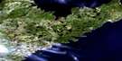
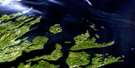
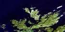
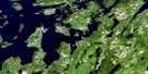
Little Fogo Islands Satellite Image Map
Download Free Aerial Photo 002E16 at 1:50,000 scale
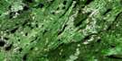
Little Fogo Islands Satellite Imagery
To view this satellite map, mouse over the air photo on the right.
You can also download this satellite image map for free:
002E16 Little Fogo Islands high-resolution satellite image map.
Maps for the Little Fogo Islands aerial map sheet 002E16 at 1:50,000 scale are also available in these versions:
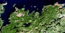
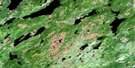
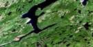
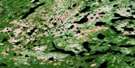
Little Fogo Islands Surrounding Area Aerial Photo Maps
 |
 |
 |
|
 |
 |
 |
 |
 |
 |
 |
 |
 |
 |
 |
 |
© Department of Natural Resources Canada. All rights reserved.
Little Fogo Islands Gazetteer
The following places can be found on satellite image map 002E16 Little Fogo Islands:
Little Fogo Islands Satellite Image: Bays
Back CoveBig Garden Cove
Deans Harbour
Joe Batts Point Cove
Little Garden Cove
Puncheon Cove
Round Harbour
Sams Gulch
Wadhams Harbour
Little Fogo Islands Satellite Image: Beaches
Eastern EndLittle Fogo Islands Satellite Image: Capes
Big Gulch of Gunning PointBig Head
Bill of Gunning Point
Bluff Point
Hawkins Point
Joe Batt's Point
Middle Gaze
Mullins Point
Norther Bill Point
Puncheon Cove Head
Little Fogo Islands Satellite Image: Islands
Amys IslandBakeapple Island
Barrack Islands
Bishops Islet
Black Dog
Black Island
Browns Island
Cellar Island
Chaulks Island
Countryman Islands
Countryman Islets
Deans Harbour Puffin Island
Double Turr Cliff
Eastern Island
Fogo Island
Freakes Island
Gappy Island
Gappy Islet
Little Fogo Island
Little Fogo Islands
Little Gappy Island
Long Island
Long Islets
Mile Islet
Mile Rock
Northeast Island
Offer Stone Island
Pentons Island
Perlican
Prestons Island
Round Island
Seals Nest Islets
Single Turr Cliff
Steering Island
Storehouse Islets
The Nuddick
The Virgins
Turr Island
Turr Islets
West Countryman Island
White Island
Little Fogo Islands Satellite Image: Shoals
Bishops RockBrogy Shoal
Drovers Rock
East Ice Ledge
Eastern Rock
Eastern Rocks
Elliot Spot
Green Bay Shoal
Gull Rock
Gunning Rock
Hard Hat
Harvey Rock
Ireland Rocks
Justegan Rock
Lanes Rocks
Lawrence Rock
Long Rocks
Middle Rock
Penny Rock
Red Rock
Rusty Rock
Storehouse Rocks
The Barracks
Turr Rocks
West Ice Ledge
© Department of Natural Resources Canada. All rights reserved.
002E Related Maps:
002E Botwood002E01 Weir's Pond
002E02 Gander River
002E03 Botwood
002E04 Hodges Hill
002E05 Robert's Arm
002E06 Point Leamington
002E07 Comfort Cove-Newstead
002E08 Carmanville
002E09 Fogo
002E10 Twillingate
002E11 Exploits
002E12 Little Bay Island
002E13 Nippers Harbour
002E14 Cape St. John
002E16 Little Fogo Islands
