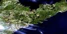
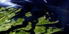
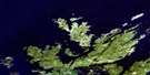
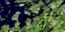
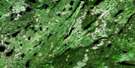
Exploits Satellite Image Map
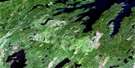
Download Free Aerial Photo 002E11 at 1:50,000 scale
Exploits Satellite Imagery
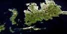
To view this satellite map, mouse over the air photo on the right.
You can also download this satellite image map for free:
002E11 Exploits high-resolution satellite image map.
Maps for the Exploits aerial map sheet 002E11 at 1:50,000 scale are also available in these versions:
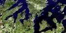
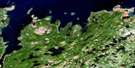
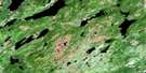
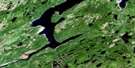
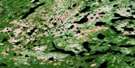
Exploits Surrounding Area Aerial Photo Maps
 |
 |
 |
|
 |
 |
 |
 |
 |
 |
 |
 |
 |
 |
 |
 |
© Department of Natural Resources Canada. All rights reserved.
Exploits Gazetteer
The following places can be found on satellite image map 002E11 Exploits:
Exploits Satellite Image: Bays
Abbott CoveArnold Cove
Bay of Exploits
Bellens Cove
Boot Cove
Burnt Cove
Burton Cove
Butler Cove
Butt Cove
Caplin Cove
Chitman Cove
Deep Gulch
Deepwater Bight
Doater Cove
Dog Fish Gulch
East Bear Cove
Exploits Lower Harbour
Exploits Upper Harbour
Farvell Cove
Fleury Bight
Fortune Harbour
Garden Cove
Grass Gulch
Green Island Cove
Gull Island Bight
Indian Cove
Jacob Cove
Job Cove
Josiah Spencer Cove
Lady Cove
Lobster Cove
Logy Cove
Longer Cove
Lower Black Point Cove
Luke Manuel Cove
Manuel Gulch
Mooring Cove
Nanny Hole
New Bay
Northwest Arm
Pig Cove
Rowsell Cove
Salmon Bight
Sealing Cove
Shoal Cove
Shoal Ground Gulch
Silver Buckle Cove
Slime Cove
Southeast Arm
Southwest Arm
Sparks Cove
Squid Cove
Squid Coves
Surgeon Cove
Tom Wall Harbour
Upper Black Point Cove
Waldron Cove
Webber Bight
West Bear Cove
West Gull Island Bight
Western Head Cove
Wild Bight
Wild Bight
Woody Island Bight
Exploits Satellite Image: Capes
Bagg HeadBall Point
Bear Head
Bellens Point
Big Head
Black Point
Breakheart Point
Crow Head
Deepwater Head
Deepwater Point
Doater Point
Eastern Head
Fox Head
Fox Point
Grebe Head
Gunning Point
Hell Grapple Head
Indian Cove Point
Lacy Head
Lacy Point
Little Marble Head
Long Point
Long Point
Lower Caplin Cove Point
Mad Moll Head
Man Point
Manuel Point
Marble Head
Moses Head
Nanny Hole Head
New Bay Head
North Head
Nosworthy Point
Perry Point
Ragged Point
Red Point
Salmon Point
Shoal Point
Sims Point
Stride Point
Surgeon Cove Point
Upper Caplin Cove Point
Waldron Cove Point
West Head
Western Head
Wild Bight Point
Exploits Satellite Image: Channels
Ship RunSloop Run
Exploits Satellite Image: Cliffs
Blow Me DownGull Cliff
Shag Cliff
Exploits Satellite Image: Islands
Alcock IslandBurnt Island
Button Island
Cull Island
Double Island
Exploits Islands
Fish Island
Gillespie Island
Gillot Island
Goat Island
Green Island
Green Island
Gull Island
Gull Island
Hamilton Island
Hare Island
High Gull Island
Jim Day Island
Keogh Island
Matthew Lane Island
North Harbour Gull Island
Pig Island
Quirk Island
Red Island
Round Island
Sculpin Island
Sculpin Island
Silver Buckle Island
Sweeny Island
Tailor Nose Island
Tarpaulin Island
Thomas Rowsell Island
Tinker Island
West Gull Island
Woody Island
Woody Island
Exploits Satellite Image: Lakes
Abbot PondAbbott Pond
Captain Cook Ponds
Squid Pond
Exploits Satellite Image: Mountains
Crows NestFortune Hill
Man of War Hill
Manuel Stores
Silver Buckle
The Lookout
Exploits Satellite Image: Sea features
Leading TicklesExploits Satellite Image: Undersea features
Tiger RockExploits Satellite Image: Shoals
Bantam RockBed Rock
Bishop Rock
Brandies Rocks
Burnt Island Ground
Callaghan Ground
Caplin Cove Banks
Cherry Ground
Chitman Spot
Colonial Bank
Cook Rock
Deepwater Bank
Eastern Bank
Eastern Ground
Friday Ledge
Friday Ledge
Friday Spot
Gruffy Ground
Gull Island Ground
Gull Island Ground
Gull Rock
Gull Rock
Gunning Rock
Gunning Rock
Halfway Ground
Harbour Bank
Harbour Rock
Hare Rock
Ice Ledge
Lanning Ground
Lilly Bank
Little Harbour Bank
Lobster Ledge
Long Point Ground
Loveman Bank
Mad Moll Rocks
Miller Rock
Naked Man
Nanny Hole Rock
New Bay Head Rocks
New Bay Head Shoal
New Ground
Nip Gut Ledge
North East Rock
North Tickle Bank
North West Bank
North West Rocks
Northern Head Ground
Offer Bed Rock
Offer Shoal Ground
Outside Spot
Paddy Outside Spot
Paddy Spot
Pelly Ground
Pipers Ledge
Red Island Bank
Sculpin Bank
Sculpin Rock
Sebright Bank
Ship Run Rock
Shoal Ground
Shoal Ground
Skinner Ledge
Snorter Ledge
South East Ground
Southern Ground
Sprunes Bank
The Field
The Ladle
Tiger Rock
Two Gull Island Ground
Walker Ledge
Western Bank
Western Ground
Western Head Rock
Woody Island Bank
Woody Island Bank
Exploits Satellite Image: Towns
Leading TicklesLeading Tickles West
Exploits Satellite Image: Unincorporated areas
Cull IslandExploits
Fleury Bight
Fortune Harbour
Moore's Cove
Waldron Cove
Exploits Satellite Image: Valleys
Black GulchCrow Gulch
© Department of Natural Resources Canada. All rights reserved.
002E Related Maps:
002E Botwood002E01 Weir's Pond
002E02 Gander River
002E03 Botwood
002E04 Hodges Hill
002E05 Robert's Arm
002E06 Point Leamington
002E07 Comfort Cove-Newstead
002E08 Carmanville
002E09 Fogo
002E10 Twillingate
002E11 Exploits
002E12 Little Bay Island
002E13 Nippers Harbour
002E14 Cape St. John
002E16 Little Fogo Islands
