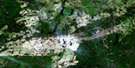
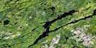
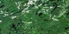
Greenhill River Satellite Image Map
Download Free Aerial Photo 042B12 at 1:50,000 scale
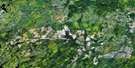
Greenhill River Satellite Imagery
To view this satellite map, mouse over the air photo on the right.
You can also download this satellite image map for free:
042B12 Greenhill River high-resolution satellite image map.
Maps for the Greenhill River aerial map sheet 042B12 at 1:50,000 scale are also available in these versions:
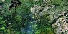
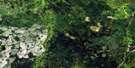
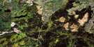
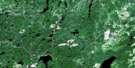
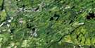
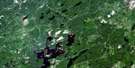
Greenhill River Surrounding Area Aerial Photo Maps
 |
 |
 |
 |
 |
 |
 |
 |
 |
 |
 |
 |
 |
 |
 |
 |
© Department of Natural Resources Canada. All rights reserved.
Greenhill River Gazetteer
The following places can be found on satellite image map 042B12 Greenhill River:
Greenhill River Satellite Image: Falls
Reva FallsGreenhill River Satellite Image: Geographical areas
AbigoAmik
Conking
Hayward
Hook
Kildare
Makawa
Mildred
Nebotik
Winget
Greenhill River Satellite Image: Lakes
Amik LakeFire Lake
Greenhill Lake
Makadawa Lake
Mildred Lake
Timia Lake
Winjiget Lake
Woodosgoon Lake
Greenhill River Satellite Image: Conservation areas
Missinaibi Provincial ParkGreenhill River Satellite Image: Rapids
Biron RapidsGreenhill River Satellite Image: Rivers
Dog RiverFire River
Gay Creek
Greenhill River
Little Nebotik River
Mildred Creek
Nebotik River
South Greenhill River
Timia Creek
Winjiget Creek
Woodosgoon Creek

© Department of Natural Resources Canada. All rights reserved.
042B Related Maps:
042B Foleyet042B01 Foleyet
042B02 Ivanhoe Lake
042B03 Swanson River
042B04 Bolkow
042B05 Missinaibi Lake
042B06 Makonie Lake
042B07 Missonga
042B08 Oswald Lake
042B09 Elf Lake
042B10 Elsas
042B11 Peterbell
042B12 Greenhill River
042B13 Minnipuka
042B14 Ericson Creek
042B15 Allenby Creek
042B16 Griffin Lake
