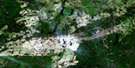
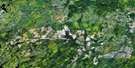
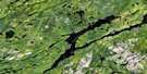
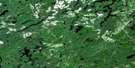
Bolkow Satellite Image Map
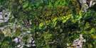
Download Free Aerial Photo 042B04 at 1:50,000 scale
Bolkow Satellite Imagery
To view this satellite map, mouse over the air photo on the right.
You can also download this satellite image map for free:
042B04 Bolkow high-resolution satellite image map.
Maps for the Bolkow aerial map sheet 042B04 at 1:50,000 scale are also available in these versions:
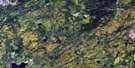
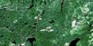
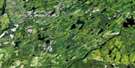
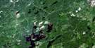
Bolkow Surrounding Area Aerial Photo Maps
 |
 |
 |
 |
 |
 |
 |
 |
 |
 |
 |
 |
 |
 |
 |
 |
© Department of Natural Resources Canada. All rights reserved.
Bolkow Gazetteer
The following places can be found on satellite image map 042B04 Bolkow:
Bolkow Satellite Image: Bays
Delmage BayGrave Bay
Lookout Bay
South Bay
Wayland Bay
Bolkow Satellite Image: Geographical areas
23,2336
37
44
Abbey
Addison
Bader
Bliss
Buckland
Chaplin
Clifton
Collishaw
D'Avaugour
Delmage
Druillettes
Hill
Hornell
Lang
Marsh
Ramsden
Bolkow Satellite Image: Lakes
Abbey LakeAce Lake
Acolyte Lake
Addison Lake
Agusada Lake
Angle Lake
Anjigaming Lake
Ash Lake
Auld Lake
Bader Lake
Badshaw Lake
Bolkow Lake
Boot Lake
Bow Lake
Buckhorn Lake
Buckram Lake
Buge Lake
Burnt Lake
Cam Lake
Centre Lake
Chaplin Lake
Clifton Lake
Cloister Lake
Coldwind Lake
Costello Lake
Curly Lake
Delmage Lake
Dorman Lake
East Chaplin Lake
Elbow Lake
Elson Lake
Fork Lake
Forty Four Lake
Four Line Lake
Fra Lake
Gee Lake
Going Lake
Goldie Lake
Grass Lake
Grosbeak Lake
Kathleen Lake
Keel Lake
Keneswabe Lake
Key Lake
Kipawa Lake
Lang Lake
Liason Lake
Lily Lake
Little Missinaibi Lake
Lum Lake
Madge Lake
Maki Lake
Mallow Lake
Mantle Lake
Matti Lake
Missinaibi Lake
Morin Lake
Musquash Lake
Neck Lake
Ogasiwi Lake
Padre Lake
Panacheese Lake
Paubil Lake
Pibroch Lake
Pilot Lake
Ramhill Lake
Ramona Lake
Ramsden Lake
Rawhide Lake
Redstart Lake
Reflection Lakes
Ribes Lake
Rocket Lake
Shemeket Lake
Slash Lake
Slee Lake
Spirit Lake
Stump Lake
Syne Lake
Tappaise Lake
Thrush Lake
Trembley Lake
Triplet Lake
Ward Lake
Web Lake
Windabaic Lake
Windermere Lake
Woods Lake
Zag Lake
Zig Lake
Bolkow Satellite Image: Conservation areas
Missinaibi Provincial ParkBolkow Satellite Image: Rivers
Abbey CreekAgusada Creek
Anjigaming River
Bader Creek
Bolkow Creek
Chaplin River
Ebony Creek
Goldie River
Little Missinaibi River
Maki Creek
Reflection Creek
Rocket Creek
Slash Creek
Stump Creek
Windermere River
Bolkow Satellite Image: Unincorporated areas
BolkowShumka
Wayland

© Department of Natural Resources Canada. All rights reserved.
042B Related Maps:
042B Foleyet042B01 Foleyet
042B02 Ivanhoe Lake
042B03 Swanson River
042B04 Bolkow
042B05 Missinaibi Lake
042B06 Makonie Lake
042B07 Missonga
042B08 Oswald Lake
042B09 Elf Lake
042B10 Elsas
042B11 Peterbell
042B12 Greenhill River
042B13 Minnipuka
042B14 Ericson Creek
042B15 Allenby Creek
042B16 Griffin Lake
