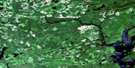
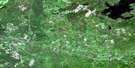
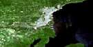
Onion Lake Satellite Image Map
Download Free Aerial Photo 052A11 at 1:50,000 scale
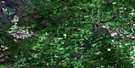
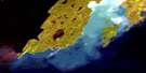
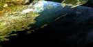
Onion Lake Satellite Imagery
To view this satellite map, mouse over the air photo on the right.
You can also download this satellite image map for free:
052A11 Onion Lake high-resolution satellite image map.
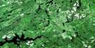
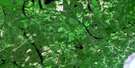
Maps for the Onion Lake aerial map sheet 052A11 at 1:50,000 scale are also available in these versions:
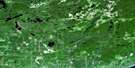
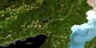
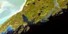
Onion Lake Surrounding Area Aerial Photo Maps
 |
 |
 |
 |
 |
 |
 |
 |
 |
 |
 |
 |
 |
 |
© Department of Natural Resources Canada. All rights reserved.
Onion Lake Gazetteer
The following places can be found on satellite image map 052A11 Onion Lake:
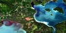
Onion Lake Satellite Image: Bays
Chief BayClarke Bay
Mary Harbour
Stirrett Bay
Thunder Bay
Onion Lake Satellite Image: Capes
Frog PointMoose Point
Onion Lake Satellite Image: Channels
Surprise Lake NarrowsOnion Lake Satellite Image: Geographical areas
FowlerGorham
Jacques
MacGregor
McIntyre
Oliver
Ware
Onion Lake Satellite Image: Islands
Net IslandToivold Island
Onion Lake Satellite Image: Lakes
Barnum LakeBasher Lake
Beaverkit Lake
Beaverlodge Lake
Bentley Lake
Bolduc Lake
Boyd Lake
Burk Lake
Carlson Lake
Crock Lake
Cummins Lake
Dog Lake
Dufault Lake
Egg Lake
Florence Lake
Flossie Lake
Fodder Lake
Freed Lake
Gilby Lake
Golding Lake
Goodman Lake
Greenhue Lake
Greenpike Lake
Gunderson Lake
Halfway Lake
Ham Lake
Hardwicke Lake
Hawkeye Lake
Hazelwood Lake
High Lake
Hornet Lake
Howcum Lake
Island Lake
Kajander Lake
Kawene Lake
Kingfisher Lake
Lake Koivukoski
Lassie Lake
Little Hawkeye Lake
Lone Island Lake
Lottit Lake
MacCormack Lake
Magone Lake
Mary Lake
Missing Lake
Monday Lake
No Name Lake
Nybergs Lake
Odette Lake
One Island Lake
Onion Lake
Paul Lake
Penassen Lakes
Rescue Lake
Retto Lake
Rosvall Lake
Shabb Lake
Spike Lake
Spirit Lake
Sunday Lake
Surprise Lake
Tapico Lake
Tapio Lake
Timmus Lake
Ton Lake
Tornroos Lake
Town Lake
Trout Lake
Two Island Lake
Two Pound Lake
Voutilainen Lake
Walkinshaw Lake
Waller Lake
Warnica Lake
Wartman Lake
Wasp Lake
Whitelily Lake
Onion Lake Satellite Image: Other municipal/district area - miscellaneous
OliverOliver Paipoonge
Paipoonge
Onion Lake Satellite Image: Rivers
Aberdeen CreekBarnum Creek
Bentley Creek
Blind Creek
Crock Creek
Current River
Escape Creek
Ferguson Creek
Hawkeye Creek
Mackenzie Creek
McIntyre River
McVicar Creek
Neebing River
Penassen Creek
Savigny Creek
Strawberry Creek
Sunday Creek
Ton Creek
Walkinshaw Creek
Wasp Creek
Wild Goose Creek
Wildgoose Creek
Onion Lake Satellite Image: Unincorporated areas
IntolaKivikoski
Lappe
Stepstone
Toimela
Onion Lake Satellite Image: Low vegetation
Barclay's Bog
© Department of Natural Resources Canada. All rights reserved.
