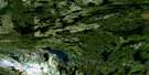
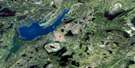
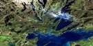
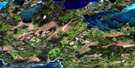
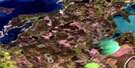
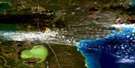
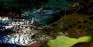
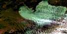
Flin Flon Satellite Image Map
Download Free Aerial Photo 063K13 at 1:50,000 scale
Flin Flon Satellite Imagery
To view this satellite map, mouse over the air photo on the right.
You can also download this satellite image map for free:
063K13 Flin Flon high-resolution satellite image map.
Maps for the Flin Flon aerial map sheet 063K13 at 1:50,000 scale are also available in these versions:
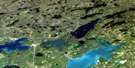
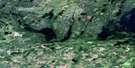
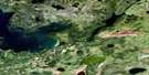
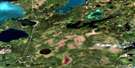
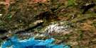
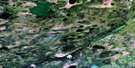
Flin Flon Surrounding Area Aerial Photo Maps
 |
 |
 |
 |
 |
 |
 |
 |
 |
 |
 |
 |
 |
 |
 |
 |
© Department of Natural Resources Canada. All rights reserved.
Flin Flon Gazetteer
The following places can be found on satellite image map 063K13 Flin Flon:
Flin Flon Satellite Image: Bays
Haskin BayHaskin Bay
Lobstick Bay
North Arm
Northwest Arm
Sourdough Bay
Thompson Bay
Weasel Bay
Weetago Bay
Flin Flon Satellite Image: City
Flin FlonFlin Flon Satellite Image: Falls
Mikanagan FallsFlin Flon Satellite Image: Islands
Big IslandMills Island
Flin Flon Satellite Image: Lakes
Alberts LakeAlleyn Lake
Amulet Lake
Animus Lake
Arthurs Lake
Athapapuskow Lake
Bartley Lake
Bath Lake
Batters Lake
Bear Lake
Beaverdam Lake
Benn Lake
Big Charlie Lake
Big Island Lake
Bluenose Lake
Bryan Lake
Cacholotte Lake
Cliff Lake
Club Lake
Cope Lake
Creighton Lake
Defender Lake
Dubnick Lake
Eagle Head Lake
Embury Lake
Flin Flon Lake
Flintoba Lake
Florence Lake
Florence Lake
Flux Lake
Forester Lake
Foul Lake
Grant Lake
Hamell Lake
Hapnot Lake
Hapnot Lake
Hidden Lake
Hilary Lake
Imperial Lake
Jenny Lake
Jersey Lake
Key Lake
Kisseynew Lake
Kisseynew Lake
Krasny Lake
Lac Aimée
Leo Lake
Limit Lake
Little Charlie Lake
Little Cliff Lake
Loughnan Lake
Louis Lake
Manistikwan Lake
Mari Lake
McBratney Lake
McMurtry Lake
McWater Lake
Meridian Lake
Mikanagan Lake
Mud Lake
Murray Lake
Naosap Mud Lake
Newman Lake
Nordick Lake
Oblong Lake
One Portage Lake
Pistol Lake
Precipice Lake
Precipice Lake
Reddy Lake
Rosenberg Lake
Ross Lake
Ross Lake
Ruby Lake
Sawmill Lake
Schist Lake
Shore Lake
Slug Lake
Smook Lake
Solodiuk Lake
Spike Lake
Standing Lake
Steeves Lake
Swordfish Lake
Tartan Lake
Thompson Lake
Tooth Lake
Triangle Lake
Two Portage Lake
Vick Lake
Wabishkok Lake
Ward Lake
Wayte Lake
Whitefish Lake
Whitehead Lake
Flin Flon Satellite Image: Military areas
Canadian Forces Station Flin FlonStation des Forces canadiennes Flin Flon
Flin Flon Satellite Image: Provinces
ManitobaSaskatchewan
Flin Flon Satellite Image: Rivers
Annabel CreekAnnabel Creek
Creighton Creek
Flin Flon Creek
Flin Flon Creek
Flintoba Creek
Kississing River
Pineroot River
Ross Creek
Ross Creek
Flin Flon Satellite Image: Towns
CreightonFlin Flon Satellite Image: Unincorporated areas
ChanningFlin Flon

© Department of Natural Resources Canada. All rights reserved.
063K Related Maps:
063K Cormorant Lake063K01 Burntwood Bay
063K02 Cormorant
063K03 Root Lake
063K04 Namew Lake
063K05 Goose Lake
063K06 Egg Lake
063K07 Yawningstone Lake
063K08 Dyce Lake
063K09 Tramping Lake
063K10 Iskwasum Lake
063K11 Cranberry Portage
063K12 Schist Lake
063K13 Flin Flon
063K14 Naosap Lake
063K15 Elbow Lake
063K16 File Lake
