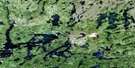
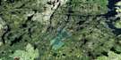
Wheatcroft Lake Satellite Image Map
Download Free Aerial Photo 064C02 at 1:50,000 scale
Wheatcroft Lake Satellite Imagery
To view this satellite map, mouse over the air photo on the right.
You can also download this satellite image map for free:
064C02 Wheatcroft Lake high-resolution satellite image map.
Maps for the Wheatcroft Lake aerial map sheet 064C02 at 1:50,000 scale are also available in these versions:
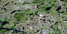
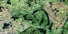
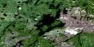
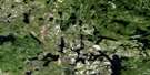
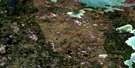
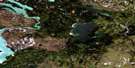
Wheatcroft Lake Surrounding Area Aerial Photo Maps
 |
 |
 |
 |
 |
 |
 |
 |
 |
 |
 |
 |
 |
 |
 |
 |
© Department of Natural Resources Canada. All rights reserved.
Wheatcroft Lake Gazetteer
The following places can be found on satellite image map 064C02 Wheatcroft Lake:
Wheatcroft Lake Satellite Image: Bays
Muhekun BayMuskwa Bay
Wapowukaw Bay
Wheatcroft Lake Satellite Image: Capes
Maymaykwachewapisk PointNeekwuhuskan Point
Wheatcroft Lake Satellite Image: Channels
Wapowukaw NarrowsWheatcroft Lake Satellite Image: Falls
Kaneesuschisik FallsKapechikocheewasik Falls
Muskwawikun Falls
Wheatcroft Lake Satellite Image: Islands
Gillespie IslandMackie Island
Mistuhe Island
Muskwanuk Island
Preston Island
Wheatcroft Lake Satellite Image: Lakes
Allen LakeAtachikomi Lake
East Muskak Lake
Elvyn Lake
Granville Lake
Kaministikowik Lake
Lambert Lake
Little Kakwu Lake
Little Mwoak Lake
Mistutaykamik Lake
Numapin Lake
Oyster Lake
Rosie Lake
Seahorse Lake
Trophy Lake
West Muskak Lake
Wheatcroft Lake
Wolfcub Lake
Wolfpack Lake
Wheatcroft Lake Satellite Image: Mountains
Davis HillWheatcroft Lake Satellite Image: Rapids
Kakakew RapidsKameetosis Rapids
Kochenipe Rapids
Okwachapeewin Rapids
Wheatcroft Lake Satellite Image: Rivers
Churchill RiverEvans Creek
Laurie River
Numakousis River
Numapin Creek
Onion River
Rivière Churchill
Wheatcroft Lake Satellite Image: Road features
Kameetosis PortageNikik Portage
Weesakiamin Portage
Wheatcroft Lake Satellite Image: Unincorporated areas
Granville Lake
© Department of Natural Resources Canada. All rights reserved.
064C Related Maps:
064C Granville Lake064C01 Suwannee Lake
064C02 Wheatcroft Lake
064C03 Mcknight Lake
064C04 Mccallum Lake
064C05 Kamuchawie Lake
064C06 Kadeniuk Lake
064C07 Watt Lake
064C08 Turnbull Lake
064C09 Eden Lake
064C10 Sickle Lake
064C11 Mcgavock Lake
064C12 Laurie Lake
064C13 Mcmillan Lake
064C14 Lynn Lake
064C15 Cockeram Lake
064C16 Barrington Lake
