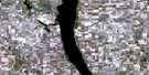
Watrous Satellite Image Map
Download Free Aerial Photo 072P11 at 1:50,000 scale
Watrous Satellite Imagery
To view this satellite map, mouse over the air photo on the right.
You can also download this satellite image map for free:
072P11 Watrous high-resolution satellite image map.
Maps for the Watrous aerial map sheet 072P11 at 1:50,000 scale are also available in these versions:
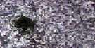
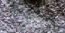
Watrous Surrounding Area Aerial Photo Maps
 |
 |
 |
 |
 |
 |
 |
 |
 |
 |
 |
 |
 |
 |
 |
 |
© Department of Natural Resources Canada. All rights reserved.
Watrous Gazetteer
The following places can be found on satellite image map 072P11 Watrous:
Watrous Satellite Image: Hamlets
LockwoodWatrous Satellite Image: Lakes
Axe LakeBank Lake
Boulder Lake
Camp Lake
Colt Lake
Little Manitou Lake
Mitt Lake
Wind Lake
Watrous Satellite Image: Other municipal/district area - miscellaneous
Morris No. 312Usborne No. 310
Viscount No. 341
Wood Creek No. 281
Wreford No. 280
Watrous Satellite Image: Conservation areas
Manitou and District Regional ParkManitou District Regional Park
Manitou Regional Park
Watrous Satellite Image: Rivers
Dellwood BrookLanigan Creek
Undora Brook
Watrous Satellite Image: Springs
Calder SpringsWatrous Satellite Image: Towns
NokomisWatrous
Watrous Satellite Image: Unincorporated areas
AmazonAmbassador
Undora
Venn
Watrous Satellite Image: Villages
DrakeManitou Beach

© Department of Natural Resources Canada. All rights reserved.
