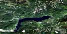
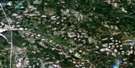
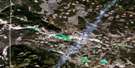
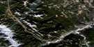
Louis Creek Satellite Image Map
Download Free Aerial Photo 092P01 at 1:50,000 scale
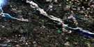
Louis Creek Satellite Imagery
To view this satellite map, mouse over the air photo on the right.
You can also download this satellite image map for free:
092P01 Louis Creek high-resolution satellite image map.
Maps for the Louis Creek aerial map sheet 092P01 at 1:50,000 scale are also available in these versions:
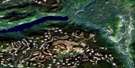
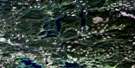
Louis Creek Surrounding Area Aerial Photo Maps
 |
 |
 |
 |
 |
 |
 |
 |
 |
 |
 |
 |
 |
 |
 |
 |
© Department of Natural Resources Canada. All rights reserved.
Louis Creek Gazetteer
The following places can be found on satellite image map 092P01 Louis Creek:
Louis Creek Satellite Image: District municipality
BarriereLouis Creek Satellite Image: Indian Reserves
Barriere River Indian Reserve 3AKamloops Indian Reserve 4
Louis Creek Indian Reserve 4
North Thompson Indian Reserve 1
Réserve indienne Barriere River 3A
Réserve indienne Kamloops 4
Réserve indienne Louis Creek 4
Réserve indienne North Thompson 1
Réserve indienne Whispering Pines 4
Whispering Pines Indian Reserve 4
Louis Creek Satellite Image: Islands
Gilead IslandLouis Creek Satellite Image: Lakes
Adler LakeAllan Lake
Badger Lake
Beauregard Lake
Black Lake
Bob Creek
Bob Lake
Bogmar Lake
Boulanger Lake
Camp Nine Lake
Cannine Lake
Caribou Lake
Couture Lake
Coyote Lake
Dagger Lake
Dewey Lake
Dumbell Lake
Dunsapie Lake
Estelle Lake
Frankie Lake
Frogpond Lake
Genier Lakes
Gorman Lake
Grant Lake
Hoopatatkwa Lake
Hoover Lake
Little Badger Lake
Lloyd Lake
Martha Lake
Martin Meadows Lake
Mayson Lake
Meighan Lakes
Mollimarn Lake
Norma Lake
Osprey Lake
Parky Lake
Pinerock Lake
Pothole Lake
Rea Lake
Renee Lake
Rexford Lake
Rock Island Lake
Rushton Slough
Shelley Lake
Siam Lake
Spooney Lake
Spooney Lakes
Struthers Lakes
Stuart Lake
Totunkwa Lake
Tsintsunko Lake
Tuwut Lake
Twin Lake
Whitewood Lake
Willowgrouse Lake
Windy Lake
Louis Creek Satellite Image: Mountains
Barrière MountainBarriere Mountains
Dixon Mountains
Dixon Ridge
Edwards Mountains
Fishtrap Mountain
Garrison Mountain
Genier Hill
Goudreau Mountains
Jamieson Range
Metoots Hill
Mount Armour
Mount Borthwick
Mount Dixon
Mount Edwards
Mount Fraser
Mount Goudreau
Mount Hagen
Mount McGregor
Parky Mountain
Poison Hill
Shuswap Highland
Skoatl Point
Skull Hill
Louis Creek Satellite Image: Major municipal/district area - major agglomerations
Thompson-Nicola Regional DistrictLouis Creek Satellite Image: Conservation areas
Bonaparte ParkTsintsunko Lakes Park
Louis Creek Satellite Image: Plains
Fraser PlateauGizzard Flats
Interior Plateau
Thompson Plateau
Louis Creek Satellite Image: Rapids
Fishtrap RapidsLouis Creek Satellite Image: Rivers
Badger CreekBarlett Creek
Barriere River
Barrière River
Bonaparte River
Bottrel Creek
Bridge Creek
Camp Nine Creek
Champ Creek
Deadman River
Dixon Creek
Fadear Creek
Fishtrap Creek
Forster Creek
Fraser Creek
Jamieson Creek
Jet Creek
Leonie Creek
Louis Creek
Mystery Creek
Nanak Creek
Nelson Creek
Noble Creek
North Thompson River
Oliver Creek
Parky Creek
Peterson Creek
Poison Creek
Sargent Creek
Sargent Creek
Skull Creek
Struthers Creek
Stuart Creek
Whitewood Creek
William Creek
Louis Creek Satellite Image: Unincorporated areas
BarrièreBlucher Hall
Chinook Cove
Exlou
Louis Creek
McLure

© Department of Natural Resources Canada. All rights reserved.
092P Related Maps:
092P Bonaparte Lake092P01 Louis Creek
092P02 Criss Creek
092P03 Loon Lake
092P04 Clinton
092P05 Jesmond
092P06 Green Lake
092P07 Bridge Lake
092P08 Chu Chua Creek
092P09 Clearwater
092P10 Deka Lake
092P11 100 Mile House
092P12 Gustafsen Lake
092P13 Chimney Lake
092P14 Lac La Hache
092P15 Canim Lake
092P16 Mahood Lake
