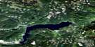
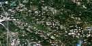
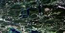
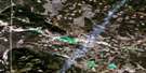
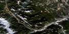
Deka Lake Satellite Image Map
Download Free Aerial Photo 092P10 at 1:50,000 scale
Deka Lake Satellite Imagery
To view this satellite map, mouse over the air photo on the right.
You can also download this satellite image map for free:
092P10 Deka Lake high-resolution satellite image map.
Maps for the Deka Lake aerial map sheet 092P10 at 1:50,000 scale are also available in these versions:
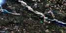
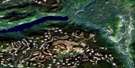
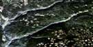
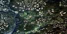
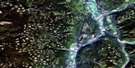
Deka Lake Surrounding Area Aerial Photo Maps
 |
 |
 |
 |
 |
 |
 |
 |
 |
 |
 |
 |
 |
 |
 |
 |
© Department of Natural Resources Canada. All rights reserved.
Deka Lake Gazetteer
The following places can be found on satellite image map 092P10 Deka Lake:
Deka Lake Satellite Image: Geographical areas
InterlakesDeka Lake Satellite Image: Islands
Long IslandDeka Lake Satellite Image: Lakes
Alans LakeApollo Lake
Balfour Lake
Bannerman Lake
Beartrap Lake
Boundary Line Lake
Bowers Lake
Bridge Lake
Carton Lake
Chris Lake
Cougar Lake
Deka Lake
Dockerill Lake
Dombey Lake
Donnely Lake
Dorrit Lake
Dragonfly Lake
Drewry Lake
Duckling Lake
East King Lake
Eastwood Lake
English Lake
Faulkner Lake
Fawn Lake
French Lake
Hathaway Lake
Hewton Lake
Higgins Lake
Lac des Roches
Lesser Fish Lake
Lonely Lake
Longbow Lake
Lorin Lake
Manning Lake
Marais Lake
Muddy Lake
Needa Lake
Otter Lake
Parks Lake
Peters Lake
Preacher Lake
Rat Lake
Reichmuth Lake
Roe Lake
Sheridan Lake
Stack Lake
Stack Lakes
Staley Lake
Sulphurous Lake
Sutherland Lake
Wavey Lake
West King Lake
Willow Lake
Wilson Lake
Deka Lake Satellite Image: Mountains
Windy MountainDeka Lake Satellite Image: Major municipal/district area - major agglomerations
Cariboo Regional DistrictDeka Lake Satellite Image: Plains
Fraser PlateauInterior Plateau
Deka Lake Satellite Image: Rivers
Balfour CreekBridge Creek
Buffalo Creek
Canimred Creek
Deka Creek
Donald Creek
Dorrit Creek
Eastwood Creek
Fawn Creek
Hathaway Creek
Jim Creek
Judson Creek
Longbow Creek
Nesachi Creek
O'Neil Creek
Webb Creek
Windy Creek
Deka Lake Satellite Image: Unincorporated areas
Deka LakeRoe Lake
Sheridan Lake

© Department of Natural Resources Canada. All rights reserved.
092P Related Maps:
092P Bonaparte Lake092P01 Louis Creek
092P02 Criss Creek
092P03 Loon Lake
092P04 Clinton
092P05 Jesmond
092P06 Green Lake
092P07 Bridge Lake
092P08 Chu Chua Creek
092P09 Clearwater
092P10 Deka Lake
092P11 100 Mile House
092P12 Gustafsen Lake
092P13 Chimney Lake
092P14 Lac La Hache
092P15 Canim Lake
092P16 Mahood Lake
