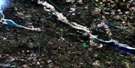
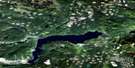
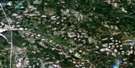
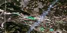
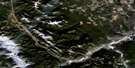
Canim Lake Satellite Image Map
Download Free Aerial Photo 092P15 at 1:50,000 scale
Canim Lake Satellite Imagery
To view this satellite map, mouse over the air photo on the right.
You can also download this satellite image map for free:
092P15 Canim Lake high-resolution satellite image map.
Maps for the Canim Lake aerial map sheet 092P15 at 1:50,000 scale are also available in these versions:
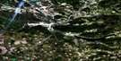
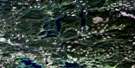
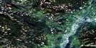
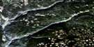
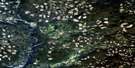
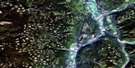
Canim Lake Surrounding Area Aerial Photo Maps
 |
 |
 |
 |
 |
 |
 |
 |
 |
 |
 |
 |
 |
 |
 |
 |
© Department of Natural Resources Canada. All rights reserved.
Canim Lake Gazetteer
The following places can be found on satellite image map 092P15 Canim Lake:
Canim Lake Satellite Image: Capes
Paul PointCanim Lake Satellite Image: Falls
Canim FallsCanim Lake Satellite Image: Indian Reserves
Canim Lake Indian Reserve 1Canim Lake Indian Reserve 5
Canim Lake Indian Reserve 6
Réserve indienne Canim Lake 1
Réserve indienne Canim Lake 5
Réserve indienne Canim Lake 6
Canim Lake Satellite Image: Islands
Canoe IslandEagle Island
Round Island
Canim Lake Satellite Image: Lakes
Baldwin LakeBeartrack Lake
Beaver Lake
Bobbs Lake
Boomerang Lake
Canim Lake
Chautemps Lake
Chris Lake
Christmas Lake
Christopher Lake
Donnely Lake
Greenlee Lake
Hawkins Lake
Hotfish Lake
Howard Lake
Judy Lake
Kellington Lake
Lang Lake
Lorin Lake
Mahood Lake
McNeil Lake
Roger Lake
Roserim Lake
Schoolhouse Lake
Squirrel Lake
Streak Lake
Succour Lake
Susan Lake
Thomson Lake
Tiny Tim Lake
Tommy Archie Lake
Weller Lake
Whale Lake
Wolf Lake
Canim Lake Satellite Image: Mountains
Mount RyanQuesnel Highland
Shuswap Highland
Canim Lake Satellite Image: Major municipal/district area - major agglomerations
Cariboo Regional DistrictCanim Lake Satellite Image: Conservation areas
Canim Beach ParkLang Lake/Schoolhouse Park
Roserim Creek Park
Schoolhouse Lake Park
Wells Gray Park
Canim Lake Satellite Image: Plains
Fraser PlateauInterior Plateau
Canim Lake Satellite Image: Rivers
Art CreekBobbs Creek
Boss Creek
Bradley Creek
Bridge Creek
Bridge Creek
Burtt Creek
Canim Creek
Canim River
Canimred Creek
Chautemps Creek
Christmas Creek
Dan MacKay Creek
Deception Creek
Devils Club Creek
Eagle Creek
Fern Creek
Hendrix (Martin) Creek
Hendrix Creek
Hotfish Creek
Jackrabbit Creek
Jim Creek
Lutely Creek
Martin Creek
Meekers Creek
Neff Creek
Roserim Creek
Spanish Creek
Squirrel Creek
Succour Creek
Terraced Creek
Thomson Creek
Webb Creek
Weller Creek
Willowswamp Creek
Canim Lake Satellite Image: Unincorporated areas
Canim LakeEagle Creek
Mahood Falls

© Department of Natural Resources Canada. All rights reserved.
092P Related Maps:
092P Bonaparte Lake092P01 Louis Creek
092P02 Criss Creek
092P03 Loon Lake
092P04 Clinton
092P05 Jesmond
092P06 Green Lake
092P07 Bridge Lake
092P08 Chu Chua Creek
092P09 Clearwater
092P10 Deka Lake
092P11 100 Mile House
092P12 Gustafsen Lake
092P13 Chimney Lake
092P14 Lac La Hache
092P15 Canim Lake
092P16 Mahood Lake
