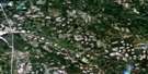
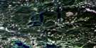
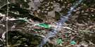
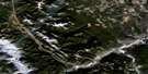
Criss Creek Satellite Image Map
Download Free Aerial Photo 092P02 at 1:50,000 scale
Criss Creek Satellite Imagery
To view this satellite map, mouse over the air photo on the right.
You can also download this satellite image map for free:
092P02 Criss Creek high-resolution satellite image map.
Maps for the Criss Creek aerial map sheet 092P02 at 1:50,000 scale are also available in these versions:
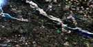
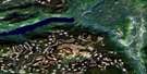
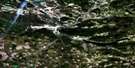
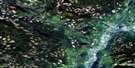
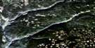
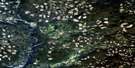
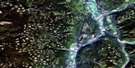
Criss Creek Surrounding Area Aerial Photo Maps
 |
 |
 |
 |
 |
 |
 |
 |
 |
 |
 |
 |
 |
 |
 |
 |
© Department of Natural Resources Canada. All rights reserved.
Criss Creek Gazetteer
The following places can be found on satellite image map 092P02 Criss Creek:
Criss Creek Satellite Image: Falls
Deadman FallsCriss Creek Satellite Image: Indian Reserves
Marshy Lake 1Criss Creek Satellite Image: Lakes
Allie LakeBare Lake
Beaverhut Lake
Bog Lake
Bonaparte Lake
Boyer Lake
Calder Lake
Chartrand Lake
Converse Lake
Deadman Lake
Duck Lake
Dumbell Lake
Elbow Lake
Enright Lake
Fatox Lake
Frankie Lake
Hammer Lake
Heller Lake
Hiahkwah Lake
Jules Lake
Kultox Lake
Lastcourse Lake
Lily Lake
Marshy Lake
Mowich Lake
Outpost Lake
Rock Lake
Sawmill Lake
Scot Lake
Secret Lake
Semlin Lake
Skookum Lake
Snohoosh Lake
Stadia Lake
Ternan Lake
Tsintsunko Lake
Tuleric Lake
Uren Lake
Vidette Lake
Willowgrouse Lake
Young Lake
Criss Creek Satellite Image: Mountains
Arrowstone HillsAvery Hill
Jerry Hill
Massey Hill
Mount Swimm
Silwhoiakun Mountain
Stockton Hill
Criss Creek Satellite Image: Major municipal/district area - major agglomerations
Thompson-Nicola Regional DistrictCriss Creek Satellite Image: Conservation areas
Castle Rock Hoodoos ParkDeadman Hoodoos Park
Criss Creek Satellite Image: Plains
Fraser PlateauInterior Plateau
Kukwaus Plateau
Thompson Plateau
Criss Creek Satellite Image: Rivers
Beaverhut CreekBrigade Creek
Coal Creek
Criss Creek
Deadman River
Hamilton Creek
Hammer Creek
Heller Creek
Joe Ross Creek
Joeross Creek
Moose Creek
Mow Creek
Scot Creek
Sherwood Creek
Tobacco Creek
Tsintsunko Creek
West Kiskatinaw River
Yard Creek
Criss Creek Satellite Image: Unincorporated areas
Criss CreekVidette

© Department of Natural Resources Canada. All rights reserved.
092P Related Maps:
092P Bonaparte Lake092P01 Louis Creek
092P02 Criss Creek
092P03 Loon Lake
092P04 Clinton
092P05 Jesmond
092P06 Green Lake
092P07 Bridge Lake
092P08 Chu Chua Creek
092P09 Clearwater
092P10 Deka Lake
092P11 100 Mile House
092P12 Gustafsen Lake
092P13 Chimney Lake
092P14 Lac La Hache
092P15 Canim Lake
092P16 Mahood Lake
