Gull Bay Topo Map Online
Download Free Topo Map Sheet 052H14 at 1:50,000 scale
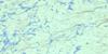
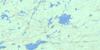
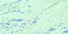
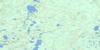
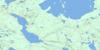
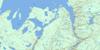
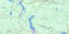
052H14 Gull Bay Topo Map
To view this map, mouse over the map preview on the right.
You can also download this topo map for free:
052H14 Gull Bay high-resolution topo map image.
Maps for the Gull Bay topo map sheet 052H14 at 1:50,000 scale are also available in these versions:
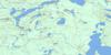
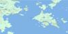
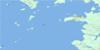
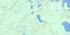
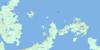
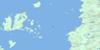
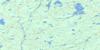
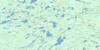
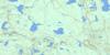
Gull Bay Surrounding Area Topo Maps
 |
 |
 |
 |
 |
 |
 |
 |
 |
 |
 |
 |
 |
 |
 |
 |
© Department of Natural Resources Canada. All rights reserved.
Gull Bay Gazetteer
The following places can be found on topographic map sheet 052H14 Gull Bay:
Gull Bay Topo Map: Bays
Duck BayGull Bay
Kaiashk Bay
Northwest Bay
Western Bay
Gull Bay Topo Map: Indian Reserves
Gull River 55Gull River Indian Reserve 55
Réserve indienne Gull River 55
Gull Bay Topo Map: Islands
Duck Bay IslandGull Bay Topo Map: Lakes
Awl LakeCarder Lake
Cooney Lake
Crevasse Lake
Cry Lake
Detour Lake
Duck Lake
Greske Lake
Guay Lake
Havoc Lake
Hornick Lake
Jackinnes Lake
Jenks Lake
Johnspine Lake
Kopka Lake
Lac Nipigon
Lake Nipigon
Log Lake
Mount Lake
Obonga Lake
Osemigwemowin Lake
Ottertooth Lake
Pangloss Lake
Pantagruel Lake
Rabelais Lake
Renaud Lake
Roder Lake
Royer Lake
Shaw Lake
Tuckaway Lake
Vooges Lake
Gull Bay Topo Map: Conservation areas
Kopka River Provincial ParkOttertooth Conservation Reserve
Pantagruel Creek Provincial Nature Reserve
Gull Bay Topo Map: Rapids
Deshaamwin RapidsPogojiwaenaun Rapids
Gull Bay Topo Map: Rivers
Awl CreekBlackwater Creek
Crazy Creek
Drunk Creek
Duck Creek
Gull River
Havoc Creek
Hornick Creek
Kaiashk River
Lawrence Creek
Ottertooth Creek
Pantagruel Creek
Rabelais Creek
Scalp Creek
Voltaire Creek
Vooges Creek
Wig Creek
Gull Bay Topo Map: Unincorporated areas
Gull Bay
© Department of Natural Resources Canada. All rights reserved.
052H Related Maps:
052H Nipigon052H01 Nipigon
052H02 Shillabeer Lake
052H03 Eaglehead Lake
052H04 Lac Des Iles
052H05 Armistice Lake
052H06 Cheeseman Lake
052H07 Black Sturgeon Lake
052H08 Orient Bay
052H09 Shakespeare Island
052H10 Grand Bay
052H11 Kabitotikwia Lake
052H12 Holinshead Lake
052H13 Uneven Lake
052H14 Gull Bay
052H15 Kelvin Island
052H16 Livingstone Point
