Antigonish Topo Map Online
Download Free Topo Map Sheet 011F12 at 1:50,000 scale
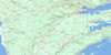
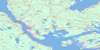
011F12 Antigonish Topo Map
To view this map, mouse over the map preview on the right.
You can also download this topo map for free:
011F12 Antigonish high-resolution topo map image.
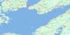
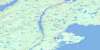
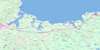
Maps for the Antigonish topo map sheet 011F12 at 1:50,000 scale are also available in these versions:
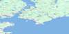
Antigonish Surrounding Area Topo Maps
 |
 |
 |
 |
 |
 |
 |
 |
 |
 |
 |
|
 |
 |
© Department of Natural Resources Canada. All rights reserved.
Antigonish Gazetteer
The following places can be found on topographic map sheet 011F12 Antigonish:
Antigonish Topo Map: Bays
Anse des BargesAntigonish Harbour
Benoits Creek
Church Cove
Church Cove
Condon Cove
Dunns Cove
Frasers Cove
George Bay
Georges Bay
Golfe du Saint-Laurent
Grahams Cove
Grahams Cove
Gulf of St. Lawrence
Havre Bouché
Havre Boucher
Henrys Cove
Jack Dans Cove
Lake Cove
Linwood Harbour
Little Tracadie Harbour
McCalls Cove
Monks Head Harbour
Norries Cove
Placides Cove
Plaster Cove
Pomquet Cove
Pomquet Creek
Pomquet Harbour
Pomquet Road
St. Georges Bay
Taylor Creek
Tracadie Harbour
Tracadie West Arm
Antigonish Topo Map: Beaches
Bayfield BeachBreens Beach
Deloreys Beach
Dunn Beach
Dunns Beach
La Batture
Linwood Beach
Mahoney Beach
Mahoneys Beach
Myettes Beach
Parishs Beach
Pomquet Beach
Rileys Beach
Seabright Beach
West Arm Beach
Antigonish Topo Map: Capes
Archibald PointArchibalds Point
Arthurs Point
Barrio Head
Barrios Head
Black Point
Bowman Head
Cape Blue
Cape Jack
Colquhoun Point
Dunn Point
Dunns Point
Ferry Point
Grahams Head
Grahams Point
Gregory Point
Gregorys Point
Indians Point
La Pointe
Lukes Point
MacIntoshs Point
MacIsaacs Point
Mackenna Point
McIsaac Point
Middle Head
Monk Head
Monks Head
Pointe à Roche
Pomquet Point
Quarry Point
Town Point
Williams Point
Antigonish Topo Map: Cliffs
Crystal CliffsAntigonish Topo Map: Forests
Dagger WoodsAntigonish Topo Map: Geographical areas
AntigonishGuysborough
Sydney
Antigonish Topo Map: Indian Reserves
Pomquet and Afton 23Summerside 38
Antigonish Topo Map: Islands
Benoit IslandBenoits Island
Big Island
Black Island
Blueberry Island
Captain Island
Captains Island
Crispos Island
Delorey Island
Delory Island
Fallis Island
Flat Island
Gooseberry Island
Grahams Island
Harris Island
Havre Island
Île à Magotte
Île aux Morts
Île du Havre
Isaacs Island
Little Island
Long Island
McCalls Island
Morrell Island
Morrett Island
Myettes Island
Perros Island
Petitpas Island
Pomquet Harbour Island
Pomquet Island
Reef Island
Sheep Island
Terrat Island
Tracadie Big Island
Antigonish Topo Map: Lakes
Archies LakeAsh Lake
Beach Pond
Bordens Lake
Boyds Lake
Boyles Lake
Breens Pond
Cameron Lake
Cape Pond
Captain Pond
Captains Pond
Carls Lake
Clam Harbour Lake
Clancys Pond
Donnellys Lake
Dunphys Lake
Étang La Mélasse
Five Mile Lake
Flynn Lake
Gavins Lakes
Gavin's Lakes
Gillis Lake
Grahams Pond
Guthros Lake
Haleys Lake
Healy Lake
Jacksons Lake
Keys Lake
Laytons Pond
Le Barachois
Leets Lake
Leet's Lake
Little Lake
Macdonald Pond
MacGillivrays Lake
Mackenna Pond
MacLeans Lake
Maynies Lake
Monk Pond
Monks Head Pond
Ogden Pond
Ogdens Pond
Pomquet Lake
Rileys Pond
Rocky Lake
Shepherd Lake
Summers Lake
Tracadie Lake
Wallace Lake
Antigonish Topo Map: Major municipal/district area - major agglomerations
AntigonishGuysborough
Antigonish Topo Map: Conservation areas
Antigonish Wildlife Management AreaAntigonish Topo Map: Rivers
Afton RiverAnna Wallaces Brook
Benoit Creek
Black Avon River
Black River
Brierly Brook
Campbells Brook
Chisholms Brook
Colin Chisholm Brook
Dagger Brook
East Branch Tracadie River
Eugenes Brook
Gormans Brook
Havre Bouché Brook
Havre Boucher Brook
Hurlburt Brook
Little Tracadie River
MacDonalds Brook
MacGillivrays Brook
McDonald Brook
McGillivray Brook
McGillivray's Brook
Meadow Bridge Brook
Meadow Brook
Meadows Brook
Meaghers Brook
Millers Brook
Monastery Brook
North Brook
North Intervale Brook
North River
North Tracadie River
Ogden Brook
Ogdens Brook
Orton Brook
Pinevale Brook
Pomquet River
Randalls Brook
Rights River
Roman Valley River
Salt Springs Brook
Silvey Brook
South River
Tates Brook
Tracadie River
Wallace Brook
West Afton River
West Pomquet River
West River
Wrights River
Antigonish Topo Map: Shoals
Bowman BankDaves Rocks
Jack Shoal
MacIsaacs Rock
McIsaac Rock
McKinleys Ledge
Pomquet Banks
The Bar
The Ledge
Antigonish Topo Map: Towns
AntigonishAntigonish Topo Map: Unincorporated areas
AftonAfton Station
Antigonish Harbour
Antigonish Landing
Barrios Beach
Bayfield
Bayfield Road
Beauly
Beech Hill
Big Tracadie
Black Avon
Black River
Boyd
Brophy
Bucklands
Cape Jack
Cloverville
Croft
Crystal Cliffs
Dagger Woods
Dunmore
East Havre Boucher
East Tracadie
Fairmont
Frankville
Fraser Mills
Frasers Grant
Fraser's Grant
Frasers Mills
Glassburn
Glenroy
Greenwold
Grosvenor
Harbour au Bouche
Harbour Centre
Harbour Road
Havre Bouché
Havre Boucher Station
Heatherton
Jimtown
Lanark
Lincolnville
Linwood
Linwood
Linwood Station
Lower South River
Lower Springfield
Mahoneys Beach
Marydale
Mattie
Mattie Settlement
McPherson
Meadow Green
Merland
Monastery
Monks Head
Morristown
New France
Pinevale
Pitcher Farm
Pitchers Farm
Pomquet
Pomquet Forks
Pomquet Station
Rear Monastery
South Merland
South River Road
South River Station
Southside Antigonish Harbour
St. Andrews
Summerside
Taylor Road
Taylors Road
Tracadie
Upper Afton
Upper Big Tracadie
Upper Pomquet
Vernal
West Arm Tracadie
West Havre Boucher
West Linwood
William Point
Williams Point
Antigonish Topo Map: Low vegetation
Boyds BogFrasers Marsh
Pomquet Intervale
The Marsh
Antigonish Topo Map: Villages
Havre Boucher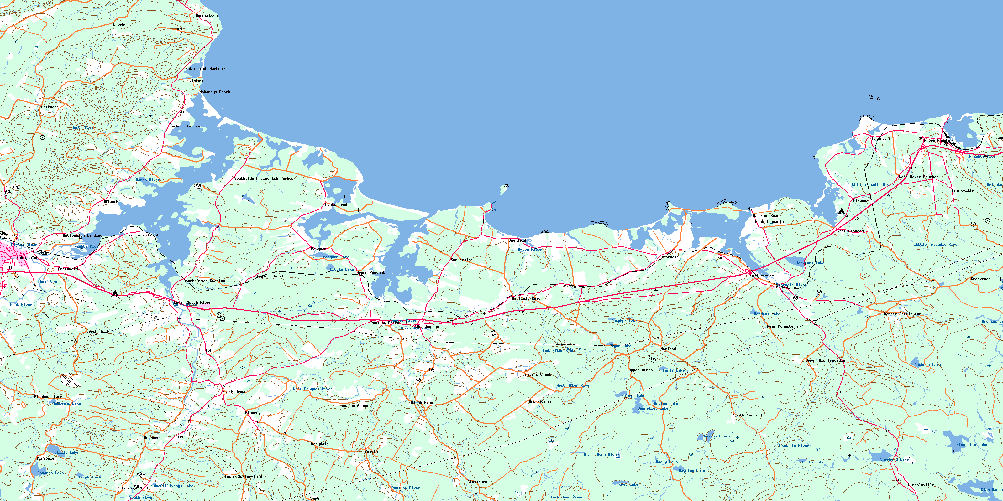
© Department of Natural Resources Canada. All rights reserved.
