Country Harbour Topo Map Online
Download Free Topo Map Sheet 011F04 at 1:50,000 scale
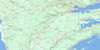
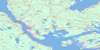
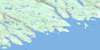
011F04 Country Harbour Topo Map
To view this map, mouse over the map preview on the right.
You can also download this topo map for free:
011F04 Country Harbour high-resolution topo map image.
Maps for the Country Harbour topo map sheet 011F04 at 1:50,000 scale are also available in these versions:
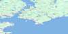
Country Harbour Surrounding Area Topo Maps
 |
 |
 |
 |
 |
 |
 |
 |
 |
 |
 |
|
 |
 |
© Department of Natural Resources Canada. All rights reserved.
Country Harbour Gazetteer
The following places can be found on topographic map sheet 011F04 Country Harbour:
Country Harbour Topo Map: Bays
Andys CoveArmstrong Creek
Barachois Cove
Barachois Cove
Baraswa Cove
Bend of Goose Island
Bettys Cove
Bill Cooks Cove
Birds Cove
Black Duck Cove
Cameron Cove
Charity Cove
Clam Cove
Coddles Harbour
Coddle's Harbour
Cooks Cove
Country Harbour
Crook Cove
Crooks Cove
Deep Cove
Devils Cupboard
Drum Head Harbour
Dung Cove
Dung Cove
Elis Cove
Fishermans Harbour
Fisherman's Harbour
Freemans Cove
Gegogan Harbour
Gillen Cove
Grave Cove
Haulover Cove
Head of Bickerton
Holland Harbour
Indian Harbour
Isaacs Harbour
Isaac's Harbour
Ishmaels Cove
Island Harbour
Jacks Cove
Jacks Cove
Jimmys Cove
Johnsons Cove
Keizers Cove
Kelp Cove
Liscomb Harbour
Little Liscomb Harbour
Long Cove
Lower Mount Cove
MacDonald Cove
Manthornes Cove
McDiarmid Cove
Mill Cove
Millards Cove
Mouton Harbour
Neverfail Cove
Northeast Arm
Northwest Arm
Northwest Cove
Pond Cove
Port Bickerton
Red Bank Cove
Sand Cove
Sandy Cove
Seal Cove
Seal Harbour
Sleepy Cove
Smoke Point Cove
Southeast Cove
Southwest Cove
St. Marys Bay
St. Mary's Bay
Stewart Cove
Teddy Cove
The Basin
The Basin
Triford Cove
Upper Mount Cove
Walter Cove
Warringtons Cove
Watering Cove
Webb Cove
Webbs Cove
Wine Harbour
Wine Harbour Bay
Country Harbour Topo Map: Beaches
Bezansons BeachHaulover Beach
Little Long Breaker
Long Breaker
Lucas Beach
Morris Beach
Port Hilford Beach
Southwest Breaker
The Bar
The Big Sand
The Clam Flats
The Fiddler
The Gravel Bar
Country Harbour Topo Map: Capes
Adams PointAndys Point
Barachois Head
Barachois Point
Beach Point
Bear Point
Bear Trap Head
Birch Head
Birch Point
Black Head
Brig Point
Burke Point
Burns Point
Byrne Head
Calf Point
Cape Gegogan
Cape Mocodome
Cape St. Mary
Cape St. Marys
Coddles Point
Coddle's Point
Coote Head
Country Harbour Head
Cranberry Point
Crook Point
Darby Point
Davidson Point
Davidsons Head
Drum Head
Drum Head
Eastern Red Head
Fiddlers Head
Fishermans Harbour Head
Fisherman's Harbour Head
Fleck Point
Flecks Point
Fly Point
Flying Point
Gaspereaux Point
Gibbs Head
Gravel Point
Green Point
Halletts Point
Harbour Point
Hemlock Point
Hinloch Point
Holland Head
Holly Point
Indian Point
Indian Point
Jimmys Point
Jims Point
Leggatt Point
Lighthouse Point
Liscomb Point
Long Point
Lucas Point
Luddington Point
Lynds Point
Millards Point
Moose Point
Neverfail Point
Normans Head
Pond Bar Point
Poole Point
Ragged Point
Red Head
Redman Head
Reids Point
Rocky Point
Rude Point
Rudolphs Point
Saladin Point
Seal Cove Head
Shag Point
Sheep Pen Point
Sheepskin Point
Shoal Point
Sinclairs Point
Smoke Point
Taylors Point
Teal Pond Point
The Head
The Nub
Triford Head
Turnip Point
West Brook Point
Wharf Point
Widow Point
Wine Head
Yellow Point
Country Harbour Topo Map: Channels
Little Folly PassageThe Narrows
The Sound
Country Harbour Topo Map: Cliffs
Bull BankBurns Bank
Cordwood Bank
Fleming Cliff
Georgie Mason Bank
Green Bank
Ox Cliff
Red Bank
Country Harbour Topo Map: Falls
Big FallsMad Falls
Country Harbour Topo Map: Geographical areas
GuysboroughCountry Harbour Topo Map: Islands
Andrews IslandBar Island
Barachois Island
Bickerton Island
Big Island
Burying Island
Calf Island
Coddles Island
Coddle's Island
Country Island
Currant Island
Darkin Island
Darling Island
Darling Islet
Drum Head Island
Flat Island
Fox Island
Goose Island
Gooseberry Island
Harbour Island
Harbour Island
Hemloe Island
Hirschfields Island
Hog Island
Hog Island
Holland Harbour Island
Horton Island
Horton Islet
Hurricane Island
Jacks Island
Liscomb Island
Long Island
Lucas Island
Mink Island
Mink Island
Mitchell Island
Money Island
One Tree Island
Point Island
Rae Island
Ram Island
Reids Island
Stroples Island
The Doughboy
The Fidler
Thrumcap Island
Tobacco Island
Turnip Island
Vessel Island
Walter Island
Wedge Island
Wilsons Island
Country Harbour Topo Map: Lakes
A.I.s LakeArchibald Lake
Back Pond
Basin Lake
Beach Ponds
Bear Lake
Bettys Cove Pond
Bickerton Little Lake
Black Pond
Bull Ridge Lake
Cains Lake
Cape Lake
Cape Pond
Cargill Lake
Coalpile Hill Lake
Cooper Lake
Cooper Shop Lake
Cranberry Lake
Cranberry Lake
Crane Lake
Dam Lake
Deer Lake
Desert Lake
Devil Lake
Fifth Lake
Fifth Lake
Fisherman Lake
Fishermans Harbour Lake
Forks Lake
Fourth Lake
Fourth Lake
Fowlers Lake
Fowler's Lake
Frasers Lake
Fraser's Lake
Freshwater Pond
Gegogan Pond
Georges Little Lake
Gillen Lake
Glade Lake
Gold Brook Lake
Gores Lake
Granite Lake
Grassy Lake
Green Hill Lake
Gregg Lake
Gull Lake
Harding Lake
Hardings Lake
Hardings Pond
Hardwood Lake
Hay Lake
Hay Lake
Head Lake
Head Lakes
Holmes Lake
Hoop Pole Hill Lake
Indian Harbour Lake
Indian Man Lake
Island Lake
Jessies Lake
Jessie's Lake
Joes Pond
Lake on the Mountain
Larrys Lake
Leonard Lake
Lily Lake
Lily Lake
Lily Pond
Little Indian River Lake
Little Lake
Little Lake
Little Lake
Long Lake
Long Lake
Long Pond
Long Pond
Long Still Lake
Loon Lake
Lucas Beach Pond
Lucys Pond
McDonald Lake
Meadow Lake
Mills Lake
Mill's Lake
Mills Pond
Mink Lake
Mitchell Lake
Monument Lake
Mud Lake
Muskrat Lake
Nauffts Lake
Neverfail Pond
New Found Out Lake
Oak Hill Lake
Ocean Lake
Otter Lake
Owl Lake
Picketts Lake
Quince Lake
Quinces Long Lake
Quinces Seven Island Lake
Reids Pond
Robinson Lake
Rocky Lake
Rocky Lake
Rocky Lake
Rocky Lakes
Rush Lake
Saltwater Pond
Seal Harbour Big Lake
Seal Harbour Lake
Second Lake
Second Lake
Sheep Pen Pond
Sherbrooke Lake
Sister Lakes
Sixth Lake
Slatterys Pond
Southwest Cove Pond
Squinces Long Lake
Squinces Seven Island Lake
Stewart Lake
Stewart North Lake
Stewart South Lake
T Lake
Tates Lake
Teal Pond
Third Lake
Third Lake
Three Corner Lake
Three Cornered Lake
Twin Lakes
Upper Indian Harbour Lakes
Weeks Pond
Country Harbour Topo Map: Mountains
Arm HillBackbone Hill
Bull Ridge
Cherry Hill
Cochrane Hill
Dickies Mountain
Dollivers Mountain
Eagle Hill
Fence Hill
Fifth Lake Mountain
Forks Hill
Hoop Pole Hill
Lake Hill
Lawsons Hill
Mount Misery
Plank Hill
Quinces Hill
Red Hill
Reids Timber Hill
Squinces Hill
Stewart Hill
Country Harbour Topo Map: Major municipal/district area - major agglomerations
GuysboroughSt. Mary's
Country Harbour Topo Map: Conservation areas
Salsman Provincial ParkCountry Harbour Topo Map: Rapids
Lower EddyUpper Eddy
Country Harbour Topo Map: Rivers
Archibald BrookArmstrong Creek
Armstrong Creek Brook
Barachois Brook
Basin Brook
Basin Lake Run
Bass Brook
Betty Brook
Bettys Cove Brook
Black Brook
Black Duck Run
Branch Brook
Canters Lake Run
Carding Mill Brook
Cooper Brook
Country Harbour River
Cross Brook
East Branch
East Branch Indian River
East Brook
Eastern Fork Stream
Eastern Forks Stream
Elis Cove Brook
Fentons Brook
Fenton's Brook
Fraser Brook
Gaspereau Brook
Gaspereaux Brook
Gegogan Brook
Gold Brook
Hallett Brook
Hardings Brook
Howlett Brook
Indian River
Indian River
Isaacs Harbour River
Isaac's Harbour River
John MacIntoshs Brook
Kissing Brook
Larrys Brook
Leonard Brook
Marsh Brook
Meadow Brook
New Harbour River
Northeast Arm Brook
Northeast Brook
Patterson Brook
Quince Brook
Quinces Brook
Roaring Brook
Rocky Brook
Scantlans Brook
Seal Harbour Run
Smell Brook
Smelt Brook
Smelt Brook
Smelt Brook
Southwest Brook
Squinces Brook
St. Mary River
St. Marys River
St. Mary's River
Stewart Mill Brook
Triford Brook
West Branch Indian River
West Brook
Country Harbour Topo Map: River features
Bridge PoolCastle Rock Pool
Eagle Hill Stillwater
Flat Rock Pool
Ford Pool
Forks Stillwater
Long Stillwater
Lower Long Stillwater
Northeast Arm Stillwater
Oak Tree Pool
Rocky Deadwaters
Round Stillwater
Triford Stillwater
Youngs Pool
Country Harbour Topo Map: Undersea features
Bill Giffin ShoalDuck Shoal
Duck Shoal
Pride Shoal
Country Harbour Topo Map: Shoals
Avondale ReefBald Rock
Bar Island Reef
Barachois Shoal
Bear Trap Ledge
Big Hawbolt Shoal
Big Ledge
Big Tobacco Rock
Bill Giffin Shoal
Bill Myer Shoal
Bingly Shoal
Black Head Shoal
Black Ledge
Black Rock
Black Rock
Bull Rock
Burke Shoal
Burns Rock
Byrne Rock
Cape Rock
Castor Rock
Castor Shoals
Channel Shoal
Channel Shoal
Cole Ledge
Coote Shoal
Crook Shoals
Crotch Ground
Davidsons Ledge
Dry Ledge
Duck Shoal
Duck Shoal
Dutch Shoal
Eastern Rock
Finchley Shoal
Flat Shoal
Fleck Shoal
Flecks Bank
Fripp Shoal
Frying Pan
Gibbs Shoal
Graham Shoal
Gravel Ledge
Gravel Shoal
Gull Ledge
Gull Nest
Gull Rock
Gunning Rock
Hail Rock
Hard Ledge
Hemisphere Rocks
Heron Rock
Holland Shoal
Hollins Shoal
Hollys Rocks
Horse Shoal
Indian Rock
Inside Annies Shoal
Inside Bull Shoal
Inside Sinker
Isaacs Shoals
Jacksons Rock
Jarvis Bank
Johns Shoal
Jumping Jack Bank
Kelp Shoal
Lawsons Shoal
Lewis Reef
Liscomb Shoal
Little Hawbolt Shoal
Little Ledge
Little Tobacco Rock
Little Tom Cod
Long Rock
Lower Bay Shoal
Lucas Ledge
MacDermid Shoal
MacDermids Rock
Mackerel Shoal
Meal Rocks
Middle Ground
Middle Ground
Middle Ledge
Middle Shoal
Nixonmate Reef
Nixonmate Shoal
Nixons Mate
Nixons Mate Shoal
Northeast Shoal
Northwestern Shoal
Old Notch
Otter Rocks
Outside Annies Shoal
Outside Sinker
Paddys Ledge
Pan Rock
Peter Shoal
Point of The Beach
Pollock Ground
Pollux Rock
Pollux Shoal
Pride Shoal
Pride Shoal
Ragged Ledge
Red Bank Shoal
Robar Rock
Rock of the Point
Rose Shoal
Rudder Place
Rude Shoal
Salmon Rocks
Seal Ledge
Seal Rock
Seal Rocks
Seal Rocks
Shag Ledge
Shag Reef
Shag Rock
Shoal Ground
Shoal Place
Sinclairs Ledge
Slate Rock
South Easter
Southeast Shoal
Southwest Cove Shoal
Squinces Ledge
Steering Reef
Stone Rock
Stopper Rock
Sunken Rock Reef
Taylor Shoal
Teal Pond Shoals
The Budget
The Budget
The Calf
The Chew
The Overfall
The Reef
The Sisters
The White Horse
Thrumcap Reef
Tobacco Ledge
Tobacco Reef
Tom Cod Rock
Tom Cod Shoals
Tom Pyes Bank
Uncle Charlies Shoal
Upper Bay Shoal
Walter Shoal
Weavers Ledge
Webb Reef
Webb Rock
Western Shoal
Wharf Rock
White Rock
White Shoal
Woozy Rock
Country Harbour Topo Map: Unincorporated areas
Bickerton WestCoddles Harbour
Coddle's Harbour
Country Harbour Mines
Drum Head
Drumhead
Fishermans Harbour
Fisherman's Harbour
Goldboro
Harpellville
Holland Harbour
Indian Harbour Lake
Isaacs Harbour
Isaac's Harbour
Isaacs Harbour North
Isaac's Harbour North
Jordanville
Liscomb
Little Liscomb
Middle Country Harbour
Port Bickerton
Port Hilford
Port Hillford
Seal Harbour
Sherbrooke
Sonora
St. Marys River
St. Mary's River
Stillwater
Stormont
Upper New Harbour
Wine Harbour
Country Harbour Topo Map: Low vegetation
Bakeapple GladeBig Plains
Fowlers Lake Bog
Hemloes Marsh
Quinces Glades
Reids Marsh
Seal Harbour Marshes
Squinces Glades

© Department of Natural Resources Canada. All rights reserved.
