Moncton Topo Map Online
Download Free Topo Map Sheet 021I02 at 1:50,000 scale
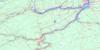
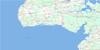
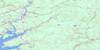
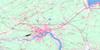
021I02 Moncton Topo Map
To view this map, mouse over the map preview on the right.
You can also download this topo map for free:
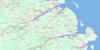
021I02 Moncton high-resolution topo map image.
Maps for the Moncton topo map sheet 021I02 at 1:50,000 scale are also available in these versions:
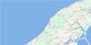
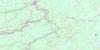
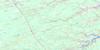
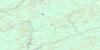
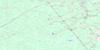
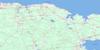
Moncton Surrounding Area Topo Maps
 |
 |
 |
 |
 |
 |
 |
 |
 |
 |
 |
 |
 |
 |
 |
 |
© Department of Natural Resources Canada. All rights reserved.
Moncton Gazetteer
The following places can be found on topographic map sheet 021I02 Moncton:
Moncton Topo Map: Bays
Shediac BayShediac Harbour
South Cove
Moncton Topo Map: Beaches
Belliveau BeachParlee Beach
Moncton Topo Map: Capes
Cape ChurchCornwall Point
Decker Point
McFarlane Point
Milne Point
Outhouse Point
Pointe-du- Chêne
Snake Point
Moncton Topo Map: Channels
Détroit de NorthumberlandNorthumberland Strait
Moncton Topo Map: City
MonctonMoncton Topo Map: Cliffs
Belliveau BluffMoncton Topo Map: Geographical areas
AlbertCoverdale
Dorchester
Moncton
Shediac
Westmorland
Moncton Topo Map: Indian Reserves
Soegao 35Moncton Topo Map: Islands
Shediac IslandMoncton Topo Map: Lakes
Folly LakeHumphreys Mills Pond
Irishtown Road Reservoir
Jones Lake
McLaughlin Road Reservoir
Melanson Settlement Lake
Moncton Reservoir
Moncton Reservoir
Moncton Topo Map: Military areas
Champ de tir MonctonMoncton Range
Moncton Topo Map: Mountains
Indian MountainLutes Mountain
Scotts Hill
Steeves Mountain
Moncton Topo Map: Conservation areas
Coverdale United ChurchÉglise unie Coverdale
Maison Pascal-Poirier
Parlee Beach Provincial Park
Moncton Topo Map: Rivers
Babineau CreekBailey Brook
Bateman Brook
Batemans Brook
Boundary Creek
Brydon Brook
Butler Creek
Calhoun Brook
Cariboo Brook
Caribou Brook
Cocagne River
Cooks Brook
Coverdale River
Decker Brook
Fox Creek
Gorge Brook
Grindstone Creek
Hall Creek
Halls Creek
Hartley Brook
Humphreys Brook
Island Creek
Jonathan Creek
Jones Brook
Lake Creek
Little River
McFarlane Creek
McQuade Brook
Meadow Brook
Memramcook River
Michaels Creek
Mill Creek
Milner Brook
Mud Creek
North Branch Cocagne River
North Branch Halls Creek
North Cocagne River
North Hall Creek
North River
Ogilvie Brook
Petitcodiac River
Prairie Brook
Rabbit Brook
Rabbit Brook
Scadouc River
Scoudouc River
Seaman Brook
Shaw Brook
Shediac River
Smith Brook
Somers Creek
South Branch Buctouche River
South Buctouche River
Steeves Creek
Stony Creek
Stony Creek
Taits Brook
Turtle Creek
Weisner Brook
West Branch Halls Creek
West Hall Creek
Wilmot Brook
Moncton Topo Map: Shoals
Ballast GroundChêne Bank
Moncton Topo Map: Towns
CoverdaleDieppe
Riverview
Shediac
Moncton Topo Map: Unincorporated areas
AllisonAmmon
Batemans Mills
Belair
Berry Mill Station
Berry Mills
Berry Mills Heights
Boundary Creek
Bridgedale
Calhoun
Canadian Heights
Cape Breton
Catamount
Centennial Place
Chapman Corner
Chartersville
Cherryfield
Codiac Heights
Cooks Brook
Coverdale
Dorchester Crossing
Dorchester Road
Dosco
Dover
East Shediac
Elmwood Estates
Evangeline
Fairview Knoll
Fox Creek
Gaytons
Gilberts Corner
Glen Cairn
Gort
Grove Hamlet
Gunningsville
Harrisville
Harrisville Station
Highland View
Hildegarde
Humphrey
Humphreys Mills
Indian Mountain
Irishtown
La Hêtrière
Lakeburn
Lakeview
Lakeville
Léger
Lewisville
Little Dover
Lower Coverdale
Lower Turtle Creek
Lutes Mountain
Lutesville
Lutz
Magnetic Hill
Malakoff
Mapleton
Mapleton Place
Marsh Junction
McGinleys Corner
McGinley's Corner
McKinnon
McQuade
Meadow Brook
Melanson Settlement
Memramcook
Memramcook East
Memramcook West
Middle Coverdale
Moncton Road
Neils Folly
New Scotland
Odlum Junction
O'Neil
Pacific Junction
Painsec
Painsec Junction
Pine Glen
Point Park
Pointe-du-Chêne
Price
Rings Corner
Riverview Heights
Saint-Anselme
Saint-Philippe
Scadouc
Scotch Settlement
Scoudouc
Shaw Brook
Shediac Cape
Shediac West
St. Philippe
St-Anselme
Steeves Mountain
Stiles Village
Stilesville
Sunny Acres
Sunny Acres West
Sunny Brae
Synton
Tankville
The Bluff
The Gorge
Upper Coverdale
Upper Dover
Valhalla Estate
Valleyview North
Weldon
West Riverview
Westend
Woodhaven Court
Moncton Topo Map: Low vegetation
Big MeadowDieppe Marsh
The Great Barren
Moncton Topo Map: Villages
Memramcook
© Department of Natural Resources Canada. All rights reserved.
021I Related Maps:
021I Moncton021I01 Port Elgin
021I02 Moncton
021I03 Salisbury
021I04 Chipman
021I05 Salmon River Road
021I06 Harcourt
021I07 Buctouche
021I08 Cape Egmont
021I09 O'Leary
021I10 Richibucto
021I11 Rogersville
021I12 Blackville
021I13 Newcastle
021I14 Kouchibouguac
021I15 Pointe-Sapin
021I16 Tignish
