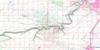
Tofield Topo Map Online
Download Free Topo Map Sheet 083H07 at 1:50,000 scale
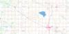
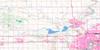
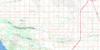
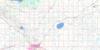
083H07 Tofield Topo Map
To view this map, mouse over the map preview on the right.
You can also download this topo map for free:
083H07 Tofield high-resolution topo map image.
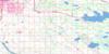
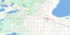
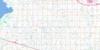
Maps for the Tofield topo map sheet 083H07 at 1:50,000 scale are also available in these versions:
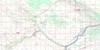
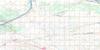
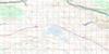
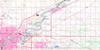
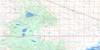
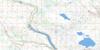
Tofield Surrounding Area Topo Maps
 |
 |
 |
 |
 |
 |
 |
 |
 |
 |
 |
 |
 |
 |
 |
 |
© Department of Natural Resources Canada. All rights reserved.
Tofield Gazetteer
The following places can be found on topographic map sheet 083H07 Tofield:
Tofield Topo Map: Capes
Military PointTofield Topo Map: Lakes
Antler LakeBeaverhill Lake
Bray Lake
Coleman Lake
Cooking Lake
Gambling Lake
Hastings Lake
Islet Lake
Larry Lake
Mac Lake
Mandy Lake
Ministik Lake
Miquelon Lakes
Oliver Lake
Owen Lake
Sisib Lake
Stove Lake
Wanisan Lake
Wat Lake
Tofield Topo Map: Major municipal/district area - major agglomerations
Beaver CountyCounty of Beaver No. 9
County of Camrose No. 22
County of Lamont No. 30
County of Leduc No. 25
Lamont County
Leduc County
Strathcona County
Tofield Topo Map: Conservation areas
Miquelon Lake Provincial ParkTofield Topo Map: Rivers
Amisk CreekHastings Creek
Katchemut Creek
Maskawau Creek
Wakinagan Creek
Tofield Topo Map: Towns
TofieldTofield Topo Map: Unincorporated areas
BardoDeville
Lindbrook
North Cooking Lake
Shonts

© Department of Natural Resources Canada. All rights reserved.
