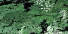
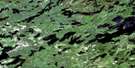
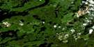
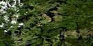
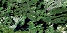
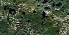
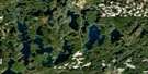
Ignace Satellite Image Map
Download Free Aerial Photo 052G05 at 1:50,000 scale
Ignace Satellite Imagery
To view this satellite map, mouse over the air photo on the right.
You can also download this satellite image map for free:
052G05 Ignace high-resolution satellite image map.
Maps for the Ignace aerial map sheet 052G05 at 1:50,000 scale are also available in these versions:
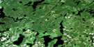
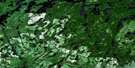
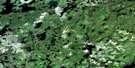
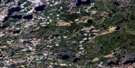
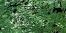
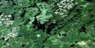
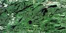
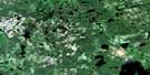
Ignace Surrounding Area Aerial Photo Maps
 |
 |
 |
 |
 |
 |
 |
 |
 |
 |
 |
 |
 |
 |
 |
 |
© Department of Natural Resources Canada. All rights reserved.
Ignace Gazetteer
The following places can be found on satellite image map 052G05 Ignace:
Ignace Satellite Image: Bays
Camp Ten BayCrocker Bay
Moose Bay
Pickerel Bay
Ignace Satellite Image: Capes
Freddie's PointIgnace Satellite Image: Channels
The NarrowsIgnace Satellite Image: Falls
Raleigh FallsIgnace Satellite Image: Geographical areas
BradshawGour
Ignace
Ilsley
Osaquan
Skey
Ignace Satellite Image: Lakes
Agimak LakeAsinn Lake
Balmoral Lake
Beresford Lake
Bigwalk Lake
Bull Lake
Butler Lake
Calf Lake
Camp Lake
Cow Lake
Davy Lake
Doreen Lake
East Revell Lake
Ekal Lake
Elbow Lake
Ford Lake
Fox Lake
Frawly Lake
Greenheart Lake
Grit Lake
Hawk Lake
Horseshoe Lake
Indian Lake
Johnson Lake
Kekwanzik Lake
Kinmoapiku Lake
Lilypad Lake
Little Asinn Lake
Little Butler Lake
Little Indian Lake
Little Raleigh Lake
Little Sandbar Lake
Lower Moosehide Lake
McNamara Lake
Michel Lake
Mill Pond
Moosehide Lake
Notman Lake
One Mile Lake
Osaquan Lake
Osaquan Lake
Owl Lake
Paddy Lake
Pinafore Lake
Pop Lake
Popeye Lake
Potter's Pond
Pratt Lake
Raleigh Lake
Roberts Lake
Robinson Lake
Sally Lake
Sandbar Lake
Shaw Lake
Shell Lake
Shellfish Lake
Three Mile Lake
Upper Moosehide Lake
Valjean Lake
West Grit Lake
Ignace Satellite Image: Mountains
Butler HillIgnace Satellite Image: Other municipal/district area - miscellaneous
IgnaceIgnace Satellite Image: Conservation areas
Sandbar Lake Provincial ParkTurtle River Provincial Park
Turtle River-White Otter Lake Provincial Park
Ignace Satellite Image: Rivers
Agimak RiverAsinn Creek
Balmoral River
Camp Creek
Campus Creek
Fox Creek
Greenheart Creek
Gulliver River
Little Wabigoon River
Nora Creek
Notman Creek
Osaquan River
Osaquan River
Owl Creek
Pratt Creek
Sally Creek
Wabigoon River
Ignace Satellite Image: Unincorporated areas
ButlerButler
Ignace
Notman
Osaquan
Raleigh

© Department of Natural Resources Canada. All rights reserved.
052G Related Maps:
052G Ignace052G01 Upsala
052G02 Firesteel River
052G03 Gulliver Lake
052G04 White Otter Lake
052G05 Ignace
052G06 Bonheur
052G07 Petry River
052G08 Pakashkan Lake
052G09 Empire Lake
052G10 Shikag Lake
052G11 Mattabi
052G12 Mameigwess Lake
052G13 Yonde
052G14 Valora
052G15 Glitter Lake
052G16 Harmon Lake
