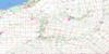
Woodstock Topo Map Online
Download Free Topo Map Sheet 040P02 at 1:50,000 scale
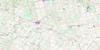
040P02 Woodstock Topo Map
To view this map, mouse over the map preview on the right.
You can also download this topo map for free:
040P02 Woodstock high-resolution topo map image.
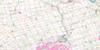
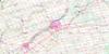
Maps for the Woodstock topo map sheet 040P02 at 1:50,000 scale are also available in these versions:
Woodstock Surrounding Area Topo Maps
 |
 |
 |
 |
 |
 |
 |
 |
 |
 |
 |
 |
 |
 |
 |
 |
© Department of Natural Resources Canada. All rights reserved.
Woodstock Gazetteer
The following places can be found on topographic map sheet 040P02 Woodstock:
Woodstock Topo Map: City
BrantBrant-on-the-Grand
Woodstock
Woodstock Topo Map: Forests
Vansittart WoodsWoodstock Topo Map: Geographical areas
BlandfordBlenheim
Brant
Burford
Dereham
Dorchester
East Nissouri
East Oxford
East Zorra
Middlesex
Nissouri
North Dorchester
North Norwich
North Oxford
Norwich
Oxford
Oxford
South Norwich
West Nissouri
West Oxford
West Zorra
Zorra
Woodstock Topo Map: Hydraulic construction
Elliott DrainHall Drain
Hamilton-Lochart Drain
Harley Drain
Hatchley Drain
Lowes-Amey Drain
McClellan Drain
Oles-Carder Drain
Tree-Radford Drain
Woodstock Topo Map: Lakes
Buchanan LakeBuck Pond
Burgess Lake
Centreville Pond
Colles Lake
Cooley Pond
Embro Pond
Fowlers Pond
Harrington Pond
Hodges Pond
Lockhart Pond
Maple Lake
Maplehurst Lake
Park Haven Lake
Pine Pond
Trotters Lake
Trout Lake
Wildwood Lake
Woodstock Topo Map: Mountains
Wolverton MountainWoodstock Topo Map: Major municipal/district area - major agglomerations
BrantMiddlesex
Oxford
Woodstock Topo Map: Other municipal/district area - miscellaneous
BlandfordBlandford-Blenheim
Blandford-Blenheim
Blenheim
Brantford
Burford
Dereham
Dorchester
Dumfries
East Nissouri
East Oxford
East Zorra
East Zorra-Tavistock
East Zorra-Tavistock
Nissouri
Nissouri
North Dorchester
North Norwich
North Oxford
Norwich
Oakland
Onondaga
South Dumfries
South Norwich
South-West Oxford
South-West Oxford
South-West Oxford
Thames Centre
West Nissouri
West Oxford
West Zorra
Zorra
Woodstock Topo Map: Conservation areas
Centreville Conservation AreaTrillium Woods Provincial Nature Reserve
Trillium Woods Provincial Park
Wildwood Conservation Area
Woodstock Topo Map: Rivers
Big CreekBig Otter Creek
Cedar Creek
Foldens Creek
Horner Creek
Kenny Creek
Middle Thames River
Mud Creek
Mud Creek
Nissouri Creek
Nith River
North Branch Creek
Otter Creek
Phelan Creek
Reynolds Creek
Rivière Thames
Thames River
Trout Creek
Whitemans Creek
Woodstock Topo Map: Towns
IngersollWestminster
Woodstock Topo Map: Unincorporated areas
BannerBeachville
Beaconsfield
Bennington
Blandford
Blandford Station
Bond's Corners
Braemar
Brooksdale
Burgessville
Cathcart
Centreville
Coakley
Cody's Corners
Creditville
Curries
Dicksons Corners
Dorland
Drumbo
Dunn's Corner
Eastwood
Embro
Folden Corners
Foldens
Forest Estates
Gobles
Golspie
Hagles Corners
Harrington
Harrington West
Hatchley
Hatchley Station
Hickson
Holbrook
Holiday
Huntingford
Innerkip
Maple Lake Park
McConkey
Muir
New Durham
New Durham Station
Oriel
Oxford Centre
Perrys Lane
Princeton
Rayside
Richwood
Showers Corners
South Zorra
Strathallan
Sweaburg
Thamesford
Tollgate
Vandecar
Walmer
Willow Lake
Windfall
Youngsville
Zorra
Zorra Station
Woodstock Topo Map: Low vegetation
Benwell SwampHatchley Swamp
Sweaburg Swamp

© Department of Natural Resources Canada. All rights reserved.
