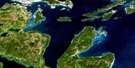
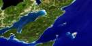
Parry Sound Satellite Image Map
Download Free Aerial Photo 041H08 at 1:50,000 scale
Parry Sound Satellite Imagery
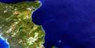
To view this satellite map, mouse over the air photo on the right.
You can also download this satellite image map for free:
041H08 Parry Sound high-resolution satellite image map.
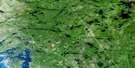
Maps for the Parry Sound aerial map sheet 041H08 at 1:50,000 scale are also available in these versions:
Parry Sound Surrounding Area Aerial Photo Maps
 |
 |
 |
 |
 |
 |
 |
|
 |
 |
||
 |
 |
 |
© Department of Natural Resources Canada. All rights reserved.
Parry Sound Gazetteer
The following places can be found on satellite image map 041H08 Parry Sound:
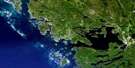
Parry Sound Satellite Image: Bays
Alves BayArmer Bay
Back Bay
Baie Georgienne
Belle Bay
Blind Bay
Boiler Bay
Boneyard Bay
Boulder Bay
Bowers Bay
Brown Bay
Brown Pool
Carling Bay
Caswell Bay
Collins Bay
Corbman Bay
Cormican Bay
Cribbie's Bay
Cunningham Bay
Deadhead Bay
Deep Bay
Deep Cove
Dent Bay
Depot Harbour
Dillon's Cove
Felsman Bay
Fitzgerald Bay
Five Mile Bay
Frederic Inlet
Georgian Bay
Gowar Bay
Guncotton Bay
Hale Bay
Hay Bay
Hulett Bay
Ireland Bay
Jacknife Harbour
Kilcoursie Bay
Kineras Bay
Kwekwekijiwan Bay
Lilypad Bay
Long Bay
Loon Bay
Matthew Bay
Mill Bay
Nutter Bay
Parry Sound
Parry Sound Harbour
Partridge Bay
Pengallie Bay
Quarry Bay
Queenie Cove
Regatta Bay
Remmie Bay
Richards Bay
Sand Bay
Sands Bay
Sawdust Bay
Shawanaga Inlet
Shebeshekong Bay
Shebeshekong Bay
Smith Bay
Snug Harbour
Snug Haven
Squirrels Cove
St. Aubyn Bay
The Keyhole
Walton Pool
West Bay
Parry Sound Satellite Image: Capes
Abbey PointAlves Point
Blackham Point
Bobs Point
Buffalo Point
Burnt Point
Burritt Point
Cadotte Point
Corbman Peninsula
Corbman Point
Craganmor Point
Cyril Point
Deepwater Point
Dillon's Point
Duncan Point
Elizabeth Point
Frances Point
Galna Point
Gell Point
Green Point
Handy Point
Hangcliff Point
Harold Point
Hawkins Point
Henrietta Point
Ireland Point
Jenkins Point
Killbear Point
Laird Point
Leisur Lee Point
Liddon Point
Louise Point
McFarlane Point
Morrison Point
Murray Point
One Mile Point
Ouimet Point
Pike Point
Pina Blanco Point
Pleasant Point
Point Louise
Pyette Point
Quinns Point
Ramsay Point
Robert Point
Robinson's Point
Rose Point
Ross Point
Salt Point
Shady Point
Shoal Point
Starkey Point
Supply Point
Ten Mile Point
Tennant Point
Three Mile Point
Tindall Point
Two Mile Point
Whitchelo Point
Parry Sound Satellite Image: Channels
Albert ChannelBarry's Channel
Canoe Channel
Clarence Channel
Devils Elbow
Five Mile Narrows
Fivemile Narrows
Hole in the Wall
Indian Dock Channel
Long Sault
Menominee Channel
Ophir Channel
Pike Channel
Ram's Horn Channel
Rose Island Channel
S Channel
Seven Mile Narrows
Sevenmile Narrows
Shebeshekong Channel
South Channel
Surprise Channel
Table Rock Channel
Three Mile Gap
Two Mile Narrows
Waubuno Channel
Parry Sound Satellite Image: Cliffs
Berket CliffHigh Bluff
Riddell Bluff
Parry Sound Satellite Image: Geographical areas
CarlingCowper
Ferguson
Foley
McDougall
Parry Sound
Shawanaga
Parry Sound Satellite Image: Indian Reserves
Parry Island First NationParry Island First Nation Indian Reserve
Parry Island Indian Reserve 16
Réserve indienne Parry Island 16
Réserve indienne Parry Island First Nation
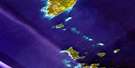
Parry Sound Satellite Image: Islands
Agassiz IslandAllen Island
Alvinholme Island
Anchor Island
Anna May Island
Anne Island
Arbour Island
Archer Island
Ardagh Island
Audrey Island
Aussie Isle
Ball Island
Bar Island
Barrett Island
Bateau Island
Beatty Island
Benz Island
Bicknell Island
Bide a Wee Island
Big McCoy Island
Big Tree Island
Birnie Island
Blackberry Island
Blairgowrie Island
Blencoe Island
Blight Island
Blizard Island
Bon Air Island
Borva Island
Bottrell Island
Boucher Island
Boville Island
Boyce Island
Boyd Island
Brayne Island
Bredin Island
Britton Island
Bromley Island
Brydon Island
Buell Island
Burgon Island
Cachia Island
Cal Island
Calhoun Island
Cameron Island
Cardinal Island
Carohoma Island
Castle Island
Cat Island
Catharine Island
Cathcart Island
Cecilia Island
Cedar Island
Chain Island
Champion Island
Channel Island
Chapman Island
Charde Island
Charlies Island
Chilco Island
Childs Island
Chippewa Island
Chlavi Island
Clode Island
Cobb Island
Colley Island
Conn Island
Coote Island
Copegog Island
Cousin Island
Cousineau Island
Crabtree Island
Cripps Island
Crow Island
Danters Island
Dart Island
Davis Island
Davy Island
Dearlove Island
Delville Island
Depot Island
Dick Island
Disney Island
Divided Island
Dixon Island
Dome Island
Downward Island
Dubeau Island
Duke Island
Dunroe Island
Edgar Island
Edge Island
Elizabeth Island
Elmtree Island
Endymion Island
Enola Island
Essex Island
Esther Island
Evelyn Island
Fairfield Island
Fairhead Island
Fairles Island
Fife Island
Forshaw Island
Fox Island
Franklin Island
Gal Island
Galna Island
Galna Island
Galt Island
Garland Island
Gaspar Island
Gaunt Island
George Island
Gertrude Island
Getty Island
Giffen Islands
Gilpin Island
Glen Island
Glencairn Island
Goat Island
Good Cheer Island
Goodkey Island
Grave Island
Green Island
Green Island
Green Island
Gull Island
Gummow Island
Haden Island
Haggart Island
Hailstone Island
Hare Island
Harold Island
Hawarden Island
Heather Island
Helens Rest Island
Heron Island
Hertzberg Island
Hooper Island
Hoover Island
Hoppner Island
Horse Island
Horsley Island
Hoxford Island
Huckleberry Island
Hydro Island
Idaho Island
Inez Island
Ingersoll Island
Ionson Island
Isabella Island
Jack Island
Jake Island
Jane Island
Johnson Island
Joiner Island
Jolliffe Island
Jones Island
Jukes Island
Keats Island
Kelvin Island
Kemp Island
Ketcheson Island
Kewis Island
Kidds Island
Killarney Island
King Island
Kingdon Island
Kneller Island
Knightsleigh Island
Kumfort Island
Lady Island
Lally Island
Lamb Island
Langhorn Island
Langridge Island
Lang's Island
Larry Island
Lawson Island
Leaming Island
Lee Island
Lenice Island
Liberty Island
Limbert's Island
Little Elmtree Island
Little McCoy Island
Little Snake Island
Lockie Island
Lockwood Island
Long Island
Longs Island
Loon Island
Loon Island
Lowndes Island
Luck Island
Lusty Island
Mahmundaug Island
Malyon Island
Manchip Island
Maple Island
Marjorie Island
Marshall Island
Martyr Islands
Mary Island
Mary Islet
Marys Island
McCormick Island
McCoy Islands
McDivitt Island
McIlray Island
McLaren Island
McLean Island
McLeod Island
McRitchie Island
Middle Island
Middle Island
Milner Island
Milton Island
Miner Island
Mingay Island
Mink Islands
Minnie Island
Moonlight Island
Morlock Island
Mowat Island
Muriel Island
Myrtle Island
Nancy Island
Narrows Island
Nash Island
Nebahwin Island
Nias Islands
North Limestone Island
Oak Island
Oak Island
Oak Islands
Old Tower Island
Osawa Island
Owen Island
Palestine Island
Palin Island
Pancake Island
Paradise Island
Parry Island
Partridge Island
Passage Island
Patterson Island
Peachey Island
Peever Island
Pell Island
Peterkin Island
Pioneer Island
Pleasant Island
Polley Island
Raper Island
Ravenscraig Island
Reid Islands
Rix Island
Robertson Island
Rockabye Island
Rockcliffe Island
Rocko Island
Rocky Rest Island
Roffey Island
Rose Island
Rosebud Island
Rosetta Island
Rumble Island
Runaway Island
Sandscliffe Island
Sandy Island
Scott Island
Searle Island
Shanahan Island
Shank Island
Shawanaga Island
Shawnee Island
Sherrynoll Island
Sing Islands
Sister Islands
Skunk Island
Skye Island
Sloan Island
Sloop Island
Snake Island
Snug Island
South Limestone Islands
Southwest Island
Sparks Island
Spectacle Island
Speers Island
Spruce Island
Squaw Island
St. Davids Island
St. Helens Island
Stalker Island
Stanley Island
Stapley Island
Stenton Island
Stoll Island
Sturdy Island
Summerhill Island
Sunny Isle
Sunnyside Island
Surprise Island
Table Rock Island
Telos Island
Terry Island
The Pancakes
Thistle Island
Thomas Island
Three Tree Island
Todd Island
Tweedie Island
Twin Island
Twin Pine Island
Twin Sisters Island
Two Domes Island
Underhill Island
Vandalis Island
Victoria Island
Violet Island
Virtue Island
Wade Island
Wall Island
Wallbank Island
Walsh Islands
Walton Islands
Warren Island
Wayne Island
Welcome Island
Weldon Island
Westbank Island
Westyle Island
Whitney Island
Wigwas Island
Windsor Island
Winflo Island
Winkler Island
Woodall Island
Woodcock Island
Woodley Island
Xile Island
Parry Sound Satellite Image: Lakes
Aikman LakeBarfoot Lake
Beaver Lake
Bell Lake
Bennett Lake
Blue Lake
Bottle Lake
Calverley's Pond
Campbell Lake
Canoe Lake
Carlson Lake
Christie Lake
Cole Lake
Conlon Lake
Cowper Lake
Cranberry Lake
Creswicke Lake
Crow Lake
Darlington Lake
Darlington's Lake
Dinner Lake
Eagle Lake
Frost Lake
Grouse Lake
Gunyon Lake
Hailstone Lake
Harris Lake
Imrie Lake
Jack Lake
Keely Lake
Lac Huron
Lake Huron
Lily Lake
Lipscombe Lake
Little Lake
Little Lakes
Little Shebeshekong Lake
Lockett Lake
Marsh Lake
Mazur Lake
McCoy Lake
McCurry Lake
McDougall Lake
McGowan Lake
Mill Lake
Miller Lake
Mirror Lake
Mountain Basin
Mud Lake
Nine Mile Lake
Nine-mile Lake
Northmore Lake
Ovens Lake
Painkiller Lake
Portage Lake
Raby Lake
Ragen Lake
Rainy Lake
Redfern Lake
Richards Lake
Richmond Lake
Richmond Lake
Rintoul Lake
Sanagan Lake
Scott Lake
Shebeshekong Lake
Simmes Lake
Spectacle Lake
Speyer Lake
Spider Lake
Spruce Lake
Square Lake
Strain Lake
Strathdee Lake
Tarver Lake
Three Legged Lake
Three Legged Lake
Three Mile Lake
Upper Marsh Lake
Verley Lake
Vicary Lake
Westphal Lake
Parry Sound Satellite Image: Other municipal/district area - miscellaneous
CarlingChristie
Foley
Georgian Bay North Archipelago
Georgian Bay South Archipelago
Humphrey
McDougall
Seguin
The Archipelago
Parry Sound Satellite Image: Conservation areas
Ferguson Township White Pine Forest Conservation ReserveKillbear Provincial Park
Round Lake Provincial Nature Reserve
The Massasauga Provincial Park
Upper Shebeshekong Wetland Conservation Reserve
Parry Sound Satellite Image: Rivers
Blair CreekBoyne River
Briar Creek
Canoe Creek
Darlington's Creek
Indian Creek
Little Shebeshekong River
Seguin River
Shebeshekong River
Thunder Creek
Parry Sound Satellite Image: Shoals
Amelia RockAraxes Bank
Ardent Rock
Ariel Rock
Arthur Orr Rock
Bailey Rock
Bassett Rock
Bayfield Rock
Beatrice Bank
Begley Rocks
Bentley Rock
Black Rock
Bogie Rock
Bogie Rocks
Borer Bank
Busty Shoal
Callady Reef
Callady Rock
Campbell Rock
Capel Rock
Carling Rock
Cataract Rock
Catherine Rock
Chesapeake Rock
Chief Rock
City Rock
Clarke Rock
Claude Rock
Colin Rock
Collins Reef
Cook Reef
Corisande Rock
Cornwallis Rock
Cracroft Rock
Cuba Rock
Davy Rock
Dent Rock
Dixon Bank
Drever Rock
Duett Rock
Eagle Rock
Edwards Bank
Farr Rock
Florence Rock
Foster Rock
Freeman Rock
Freeman Shoal
Gladman Rock
Gordon Rocks
Green Island Bank
Griper Bank
Hall Rock
Hannah Rock
Harbour Reef
Harbour Rocks
Harrison Bank
Hecla Rock
Hercules Bank
Hudgen Rock
Hugh Rock
Iron Rock
Isaiah Rock
Jack Reef
James Rock
Julia Reef
Keegan Rock
Kenneth Patches
Kerr Rock
Knight Shoal
Lawrence Rock
Lawson Rock
Louth Rock
Lyon Rocks
Marquis Rock
McClelland Rock
McCoy Shoal
McGowan Rock
McIntyre Shoal
McKerrel Rock
Middle Ground
Midland Bank
Miller Rock
Milo Rock
Miner Rocks
Minnie Rock
Newburn Rock
Nias Rocks
Niger Rock
Orlebar Rock
Pease Rock
Phoebe Rocks
Pratt Shoal
Provo Shoal
Red Rock
Richmond Rock
Savage Rocks
Sceptre Bank
Shannon Rock
Silbow Rock
Skiff Rock
Snake Bank
Solomon Rock
Spilsby Rock
Spruce Island Shoal
Spruce Rocks
Stanley Rock
Telegram Rock
Threestar Shoal
Tranch Rock
Trent Rock
Twin Rock
Vankoughnet Ground
Victor Bank
Wallace Rock
Wallis Rocks
Wave Rock
Young Rock
Parry Sound Satellite Image: Towns
Parry SoundParry Sound Satellite Image: Unincorporated areas
AdanacBadger's Corners
Brooks Landing
Carling
Depot Harbour
Dillon
Franklin Park
Killbear Park
Madigans
Nobel
North Parry
Parry Island
Rose Point
Seven Mile Narrows
Shebeshekong
Snug Harbour
Snug Haven
South Parry
Waubamik
Woods
Parry Sound Satellite Image: Low vegetation
Kichimashkosing Marsh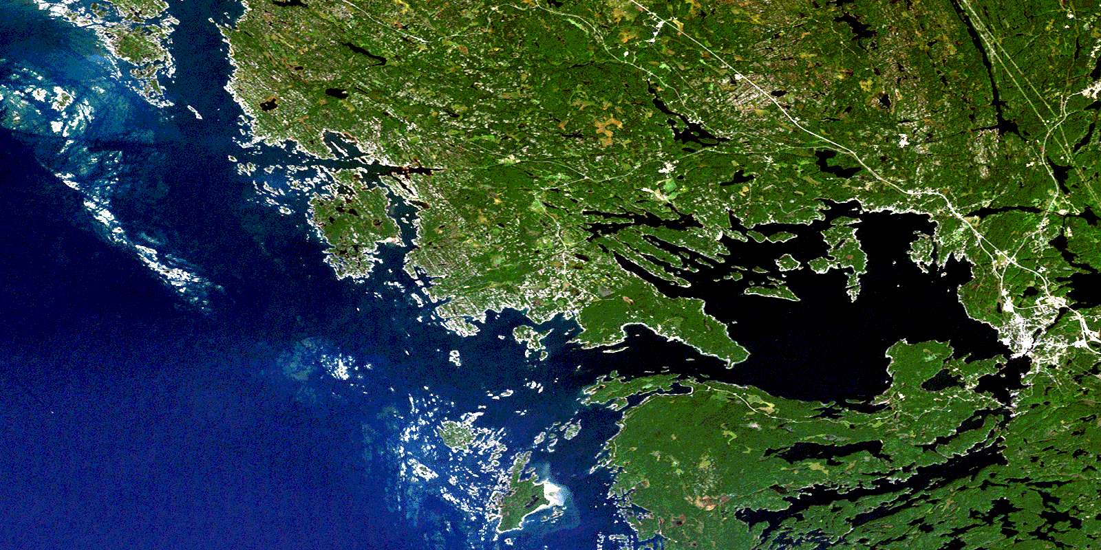
© Department of Natural Resources Canada. All rights reserved.
