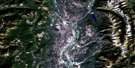
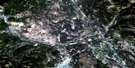
Queen Creek Satellite Image Map
Download Free Aerial Photo 082G14 at 1:50,000 scale
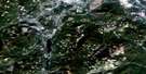
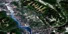
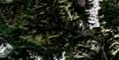
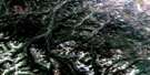
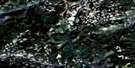
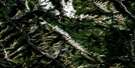
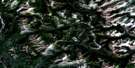
Queen Creek Satellite Imagery
To view this satellite map, mouse over the air photo on the right.
You can also download this satellite image map for free:
082G14 Queen Creek high-resolution satellite image map.
Maps for the Queen Creek aerial map sheet 082G14 at 1:50,000 scale are also available in these versions:
Queen Creek Surrounding Area Aerial Photo Maps
 |
 |
 |
 |
 |
 |
 |
 |
 |
 |
 |
 |
 |
 |
 |
 |
© Department of Natural Resources Canada. All rights reserved.
Queen Creek Gazetteer
The following places can be found on satellite image map 082G14 Queen Creek:
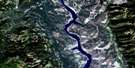
Queen Creek Satellite Image: Lakes
Fish LakeRuault Lake
Sparkle Lake
Summer Lake
Queen Creek Satellite Image: Mountains
Chrysler PeakEmpire State Peak
Hughes Range
Kootenay Ranges
Montagnes Rocheuses
Mount Dingley
Mount Doolan
Mount Frayn
Mount Gagnebin
Mount Gydosic
Mount Haynes
Mount Herchmer
Mount Morro
Mount Roth
Mount Ruault
Mount Terrion
Mount VanBuskirk
Mount Washburn
Park Ranges
Phillips Peak
Quinn Range
Rocky Mountains
Swanson Peak
Van Nostrand Range
Queen Creek Satellite Image: Major municipal/district area - major agglomerations
Regional District of East KootenayQueen Creek Satellite Image: Conservation areas
Top of the World ParkQueen Creek Satellite Image: Rivers
Akoo CreekAldertree Creek
Alpine Creek
Basin Creek
Blackfoot Creek
Boivin Creek
Bull River
Burns Creek
Coyote Creek
Cummings Creek
East Wild Horse River
Elk River
Galbraith Creek
Goat Creek
Goathoof Creek
Kowutl Creek
Lussier River
Netherlands Creek
Nicol Creek
Norboe Creek
Nordstrum Creek
North Galbraith Creek
Nukpook Creek
Queen Creek
Quinn (Queen) Creek
Quinn Creek
Ross Creek
Ruault Creek
Sprucecone Creek
Summer Creek
Telford Creek
Weigert Creek
Wild Horse River
Queen Creek Satellite Image: Valleys
Hornaday PassTop of the World

© Department of Natural Resources Canada. All rights reserved.
082G Related Maps:
082G Fernie082G01 Sage Creek
082G02 Inverted Ridge
082G03 Lake Koocanusa
082G04 Yahk River
082G05 Moyie Lake
082G06 Elko
082G07 Flathead Ridge
082G08 Beaver Mines
082G09 Blairmore
082G10 Crowsnest
082G11 Fernie
082G12 Cranbrook
082G13 Skookumchuck
082G14 Queen Creek
082G15 Tornado Mountain
082G16 Maycroft
