St Claude Topo Map Online
Download Free Topo Map Sheet 062G09 at 1:50,000 scale
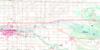
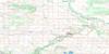
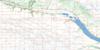
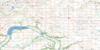
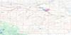
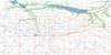
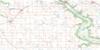
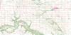
062G09 St Claude Topo Map
To view this map, mouse over the map preview on the right.
You can also download this topo map for free:
062G09 St Claude high-resolution topo map image.
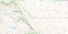
Maps for the St Claude topo map sheet 062G09 at 1:50,000 scale are also available in these versions:
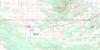
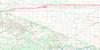
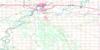
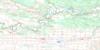
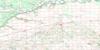
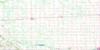
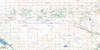
St Claude Surrounding Area Topo Maps
 |
 |
 |
 |
 |
 |
 |
 |
 |
 |
 |
 |
 |
 |
 |
 |
© Department of Natural Resources Canada. All rights reserved.
St Claude Gazetteer
The following places can be found on topographic map sheet 062G09 St Claude:
St Claude Topo Map: Hydraulic construction
Carman DamOverhill Drain
Stephenfield Dam
St Claude Topo Map: Lakes
Lac à ParkerLake Benoit
Stephenfield Lake
St Claude Topo Map: Mountains
Pembina HillsPembina Mountain
St Claude Topo Map: Other municipal/district area - miscellaneous
DufferinGrey
Lorne
South Norfolk
St Claude Topo Map: Conservation areas
Stephenfield Game Bird RefugeStephenfield Provincial Park
Stephenfield Provincial Recreation Park
St Claude Topo Map: Rivers
Boyne RiverElm Creek
Elm Creek Channel
Roseisle Creek
St Claude Topo Map: Towns
CarmanSt Claude Topo Map: Unincorporated areas
AlmasippiBradburn
Elm Creek
Graysville
Haywood
Magnus
Roseisle
Stephenfield
St Claude Topo Map: Low vegetation
Bonnet SwampDacquays Slough
Dagesse Slough
Ducharmes Slough
Dupras Sloughs
Durands Slough
Ferguson Slough
Godard Sloughs
Jones Slough
Perreaults Slough
Sharpe Slough
Souque Slough
St Claude Topo Map: Villages
St. Claude
© Department of Natural Resources Canada. All rights reserved.
