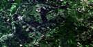
Minto Satellite Image Map
Download Free Aerial Photo 021J01 at 1:50,000 scale
Minto Satellite Imagery
To view this satellite map, mouse over the air photo on the right.
You can also download this satellite image map for free:
021J01 Minto high-resolution satellite image map.
Maps for the Minto aerial map sheet 021J01 at 1:50,000 scale are also available in these versions:
Minto Surrounding Area Aerial Photo Maps
 |
 |
 |
 |
 |
 |
 |
 |
 |
 |
 |
 |
 |
 |
 |
 |
© Department of Natural Resources Canada. All rights reserved.
Minto Gazetteer
The following places can be found on satellite image map 021J01 Minto:
Minto Satellite Image: Bays
Flowers CovePrince Cove
Printz Cove
Minto Satellite Image: Beaches
Wuhrs BeachMinto Satellite Image: Capes
McMann PointRobinson Point
Stony Point
Minto Satellite Image: Geographical areas
CanningChipman
Maugerville
Northfield
Queens
Saint Marys
Sheffield
Sunbury
Waterborough
Minto Satellite Image: Islands
Bear IslandButternut Island
Goat Island
Long Island
Minto Satellite Image: Lakes
Alexs PondArrowhead Pond
Boomerang Pond
Breeze Pond
Burpee Lake
Cattail Pond
Clare Lake
Crystal Pond
Dorsey Lake
Dougtom Pond
Elm Tree Pond
Grand Lake
Graves Pond
Horsetail Pond
Layden Pond
Lucky Pond
Milky Pond
Mills Pond
Mustang Pond
Outlet Pond
Pitcher Pond
Pond in the River
Princess Pond
Puddle Pond
Reef Pond
Ryder Lake
Shale Pond
Speculator Pond
Spruce Lake
Spruce Pond
Squaretail Pond
Sturtevant Pond
Sundew Pond
Tapley Lake
Tapley Pond
Timber Lake
Timber Pond
Turtle Pond
Upper Crystal Pond
Wangytang Pond
Wrestler Ponds
Minto Satellite Image: Mountains
Mount HopeSewell Ridge
Minto Satellite Image: Conservation areas
Refuge d'oiseaux de l'Île du CorossolMinto Satellite Image: Rivers
Albright BrookBailey Brook
Bailey Brook
Barton Brook
Baxter Brook
Bear Brook
Beaver Brook
Bull Pasture Brook
Burntbrow Brook
Burpee Mill Stream
Burpee Millstream
Butler Brook
Cains River
Clare Brook
Conroy Brook
Doherty Creek
Dorsey Brook
East Branch Penniac Stream
East Brook
East Brook
East Penniac Stream
Eighteen Brook
Estey Brook
Flower Brook
Flowers Brook
Fork Brook
Fulton Brook
Gilchrist Brook
Gormley Brook
Gosnell Brook
Grand Lake Little River
Highbank Brook
Hiltz Brook
Holland Brook
Horseback Brook
Howard Brook
Hume Brook
Hungry Brook
Hurley Brook
Hurley Creek
Hurley Creek
Jeffrey Brook
Little Burpee Brook
Little River
Little Stoney Brook
Lyon Brook
Lyons Brook
McKenzie Brook
Moonshine Brook
Moosehole Brook
Mount Pleasant Brook
Mowatt Brook
Newcastle Creek
Niles Brook
Noonan Stream
North Branch East Brook
North Branch Penniac Stream
North Forks Stream
North Penniac Stream
Penniac Stream
Penniac Stream
Perley Brook
Peter Brook
Pond Stream Brook
Red Brook
Red Brook
Red Pine Brook
Reece Brook
Ryder Brook
South Branch East Brook
Stoney Brook
Sullivan Brook
Sunbury Creek
Sutherland Brook
Upper Bailey Brook
Vance Brook
Veness Brook
Wasson Brook
West Branch Baltimore Stream
Wildcat Brook
Yeamans Brook
Minto Satellite Image: River features
Big ForksBurpee Deadwater
Clare Brook Deadwater
Little Forks
Minto Satellite Image: Unincorporated areas
Albright CornerAlbrights Corner
Avon
Butler
Cantor
Doherty
Duffys Corner
Flowers Cove
Hardwood Ridge
Humphrey Corner
Linton
Lower Durham
Mount Hope
New Avon
New England Settlement
New Zion
Newcastle Bridge
Newcastle Creek
North Minto
Northfield
Rothwell
Scale
Slope Road
South Minto
Sunbury
Upper Penniac
Minto Satellite Image: Low vegetation
Bull Pasture PlainsCranberry Bog
Dorsey Heath
Lauder Heath
The Cranberry Bog
Minto Satellite Image: Villages
Minto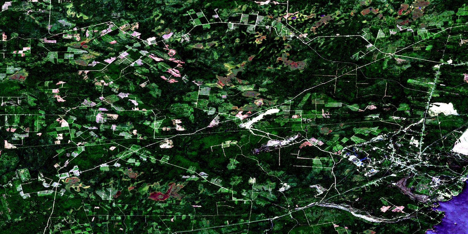
© Department of Natural Resources Canada. All rights reserved.
021J Related Maps:
021J Woodstock021J01 Minto
021J02 Burtts Corner
021J03 Millville
021J04 Woodstock
021J05 Florenceville
021J06 Coldstream
021J07 Napadogan
021J08 Boiestown
021J09 Doaktown
021J10 Hayesville
021J11 Juniper
021J12 Perth-Andover
021J13 Aroostook
021J14 Plaster Rock
021J15 Tuadook Lake
021J16 Mckendrick Lake
